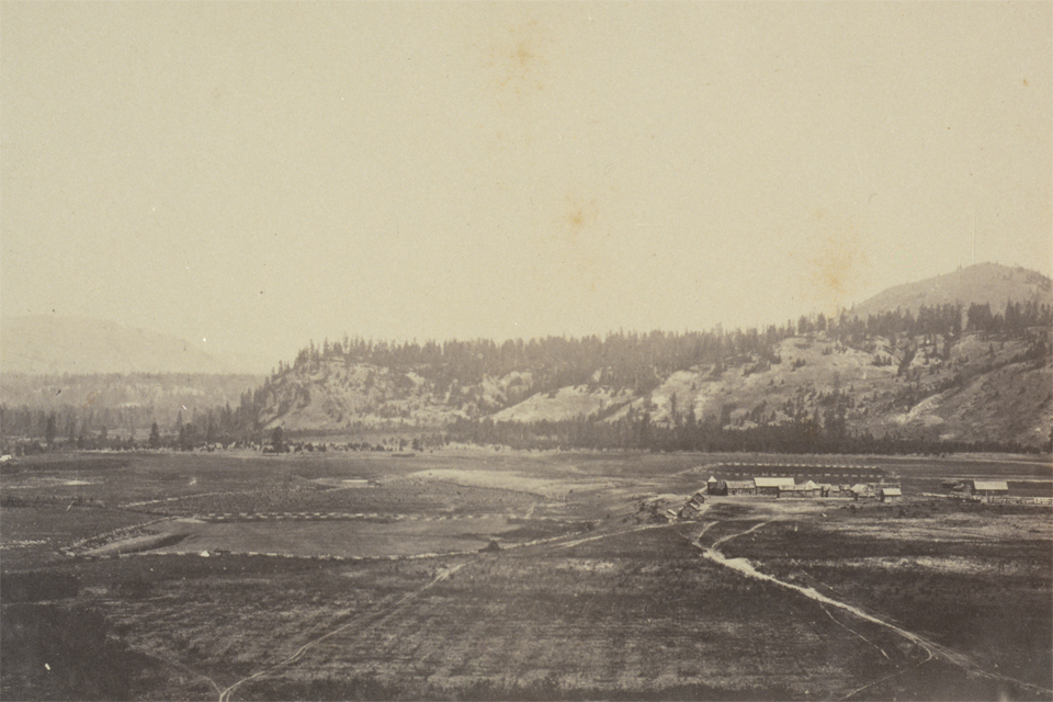
This photograph was the first I posted on the website. Given that Kettle Falls had long been the inland cultural centre for my general stomping grounds of the northwest, I guess its appropriate.
I came to your Fort Colvile page and noticed you could have a lot more hits. I have found that the key to running a website is making sure the visitors you are getting are interested in your subject matter. There is a company that you can get visitors from and they let you try their service for free. I managed to get over 300 targeted visitors to day to my site. {Check it out here:|Visit them http://bysb.eu/4rq9
Your Photos of Joseph’s Prairie, which eventually became Cranbrook, don’t quite line up with the two locations.
The original one from George Dawson, is actually taken in Baker Park and is one of two taken that day. It’s across the City from the location of your Modern version.
But your other photos like this are amazing and Thank you for capturing the past and blending it with the present!
Dan
If you’re in the mood, get a new retake and give me a bit of story on how you lined things up and I can post this (with just a reference to “Dan from Cranbrook” if you want to stay on the downlow)… I guess if you knew the actual location of that old cabin that would tell the story!!
I have a bit of a backlog of Dawson photos that need retaken around Cranbrook/Ft Steele that might be a bit of a challenge if you are interested.
12 Comments
This photograph was the first I posted on the website. Given that Kettle Falls had long been the inland cultural centre for my general stomping grounds of the northwest, I guess its appropriate.
I came to your Fort Colvile page and noticed you could have a lot more hits. I have found that the key to running a website is making sure the visitors you are getting are interested in your subject matter. There is a company that you can get visitors from and they let you try their service for free. I managed to get over 300 targeted visitors to day to my site. {Check it out here:|Visit them http://bysb.eu/4rq9
Thanks Tina…
I am going to put up another chapter before getting too keen on attracting viewers!!
Cliff
some truly prize content on this internet site , bookmarked .
thx Parajumpers…its fun to do these re-photos!!
Cliff
Hi Cliff
Do you know much about the area around Dawson Creek BC and the Kiskatinaw River area.
Liz
Liz this is a bit further north than my main interest area…. maybe some day I’ll have a look for some old photos.
Cliff
Hi Cliff,
Is the Bison population intensity map you posted on “Valleys of Bison, Rivers of Salmon” from Roe’s The North American Buffalo?
Just curious since I am interested in mapping a Bison Corridor to see if we can bring one back.
Thanks
Jon,
I’ll send you an Email with Google Earth points of first person journal bison observations, and wallow-counts that were used here.
Cliff
Your Photos of Joseph’s Prairie, which eventually became Cranbrook, don’t quite line up with the two locations.
The original one from George Dawson, is actually taken in Baker Park and is one of two taken that day. It’s across the City from the location of your Modern version.
But your other photos like this are amazing and Thank you for capturing the past and blending it with the present!
Dan
Thx Dan…
If you’re in the mood, get a new retake and give me a bit of story on how you lined things up and I can post this (with just a reference to “Dan from Cranbrook” if you want to stay on the downlow)… I guess if you knew the actual location of that old cabin that would tell the story!!
I have a bit of a backlog of Dawson photos that need retaken around Cranbrook/Ft Steele that might be a bit of a challenge if you are interested.
cliff…
Love your website!