

Changing Fire Regimes on the Yellowstone
The range in elevation from the Yellowstone River flowing along the bottom of Paradise Valley to the summit ridges of the Absoraka Range provides a good opportunity to visualize changing long-term fire regimes. Clearly much of Paradise Valley was frequently burned in the 1800s, and a lack of fires since then has resulted in increased forest cover in the recent photograph.1 By carefully looking at the historical photograph we can see more detailed patterns. The middle slopes of the Absorakas clearly burned hot, killing all the trees. Being relatively moist much of the year, these fires would have had to occur in mid to late summer– razing whole mountain-sides. But look at the fire pattern on the lower slopes of the middle ridge in the 1870s picture. Here a burn stopped at mid-slope, leaving a straight line of surviving older trees. What caused this? Probably this was spring burn than spread upwards until hitting wet soils and the melting snowpack. The cause of either these early season burns, or a late season burn outside the lightning season would likely have been native peoples, and many ecologists believe that human ignitions far outnumbered lightning fires in past times, and because they occurred year-round, created a wider range of burning patterns. 2
Further evidence for this eco-cultural fire regime is provided by several tree ring studies of Yellowstone’s regional fire patterns. Lower elevation grasslands and meadows burned most frequently (every 10 to 30 years), middle elevations and steep mountains next to these grasslands had longer fire intervals averaging about 100 years, and the large high elevation plateau near Yellowstone Lake had long periods between large fires (every 200 to 300 years). 3 The United States LANDFIRE project has mapped this fire history pattern across the Yellowstone landscape, and we can contrast this with the pattern of the area burned in the 1988 fires:
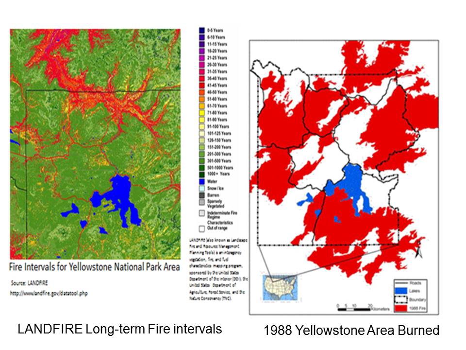
In the historical fire interval map we can see the pattern of frequent fires with intervals <50 years along the Yellowstone River and Paradise Valley north of the park (upper left part of picture), the intermediate fire frequency of about 100 years in the Absorakas (on the upper right side), and the long intervals of >200 years between burns around Yellowstone Lake on the subalpine plateau.
Now contrast this burning pattern with the large fires that occurred in 1988 in Yellowstone, which constitute by far the majority of are burned since the 1800s. What stands out is that the landscape level burning pattern in 1988 is nearly inverted to the long-term pattern predicted by LANDFIRE. Areas that used to burn frequently historically such as Yellowstone River valley were not burned, and areas that burned most infrequently in the past such as the Yellowstone plateau were heavily burned. Given that the 1988 fires represent the majority of the area burned since park establishment, this change in spatial pattern is interesting. What is causing this inverted pattern between long-term and modern Yellowstone fire regimes? Why do areas that used to burn frequently historically not burn today? Why does the majority of the area burned occur in areas where fire was historically the most infrequent?
Researchers propose several interacting factors are occurring in the Yellowstone ecosystem:
- First, and likely most importantly, long-term cultural burning is now removed. These fires most frequently occurred in shoulder seasons along valley bottoms and on warm/dry low elevation slopes, and did not spread into upper elevation areas that might still be snow-covered. Modern land management agencies in the Yellowstone area have not replaced this long-term fire regime with aggressive prescribed burning programs.
- Today, the fires that burn most the area are in mid-summer droughts, and are often ignited by lightning, or unplanned human sources. Although many of these fires may receive initial attack action, if drought conditions are severe enough they may still exceed suppression capabilities and burn large areas. Thus, over time, it is the fires that occur in the driest conditions that ultimately burn the most area. For example, in 1988, the largest fire was lit by humans, and received sustained suppression action from its first report.
- Removal of the smaller spring and fall burns over time leads to large areas of continuous dense forests that tend to burn as large patches during the mid-summer season burns described above, and;
- Within Yellowstone National Park, many grasslands and riparian areas are intensively browsed and grazed by elk and bison at densities greatly exceed historic conditions. These animals now remove the grass and shrubs that historically fueled frequent fires at lower elevations.
Cumulatively, these factors have greatly changed Yellowstone’s long-term fire regime. Over the next decades, land management agencies in the region will have to evaluate whether a return to long-term ecosystem states and processes is a useful goal, or whether the current “boom or bust” regime will continue.
Map
- Gruell, G. E. Fire and Vegetative Trends in the Northern Rockies: Interpretations from 1871–1982 Photographs. USDA Forest Service General Technical Report INT-158. Ogden, UT: Intermountain Forest and Range Experiment Station, 1983. ↩
- Kay, C.E. “Are Lightning Fires Unnatural? A Comparison of Aboriginal and Lightning Ignition Rates in the United States.” Pages 16–28 in R.E. Masters and K.E.M. Galley (eds.). Proceedings of the 23rd Tall Timbers Fire Ecology Conference: Fire in Grassland and Shrubland Ecosystems. Tall Timbers Research Station, Tallahassee, FL, 2007; White, C.A., D. D. B. Perrakis, V. G. Kafka, and T. Ennis. “Burning at the Edge: Integrating Biophysical and Eco-Cultural Fire Processes in Canada’s Parks and Protected Areas.” Fire Ecology 7 (2011): 74-106. ↩
- See Houston, D. B. “Wildfires in Northern Yellowstone National Park”. Ecology 54: 1111-1117 for valley bottom grasslands; Barrett, S.W., Fire Regimes on Andesitic Mountain Terrain in Northeastern Yellowstone-National-Park, Wyoming. International Journal of Wildland Fire 4(2) 65 – 76, 1994 for mountain areas; and for the Yellowstone Plateau: Romme, W. H., Fire and Landscape Diversity in Subalpine Forests in Yellowstone National Park. Ecological Monographs 52: 199-221. ↩