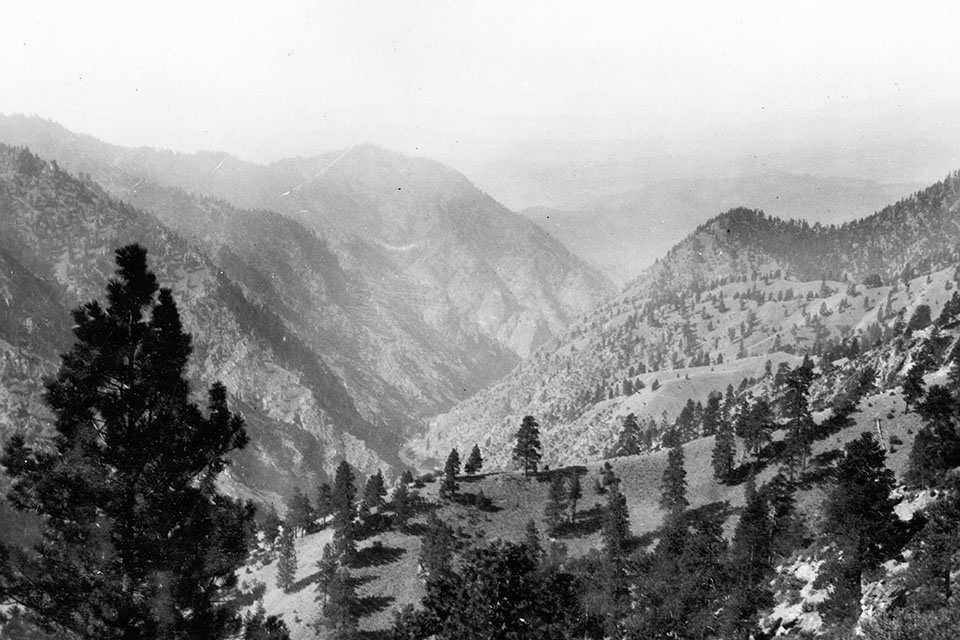
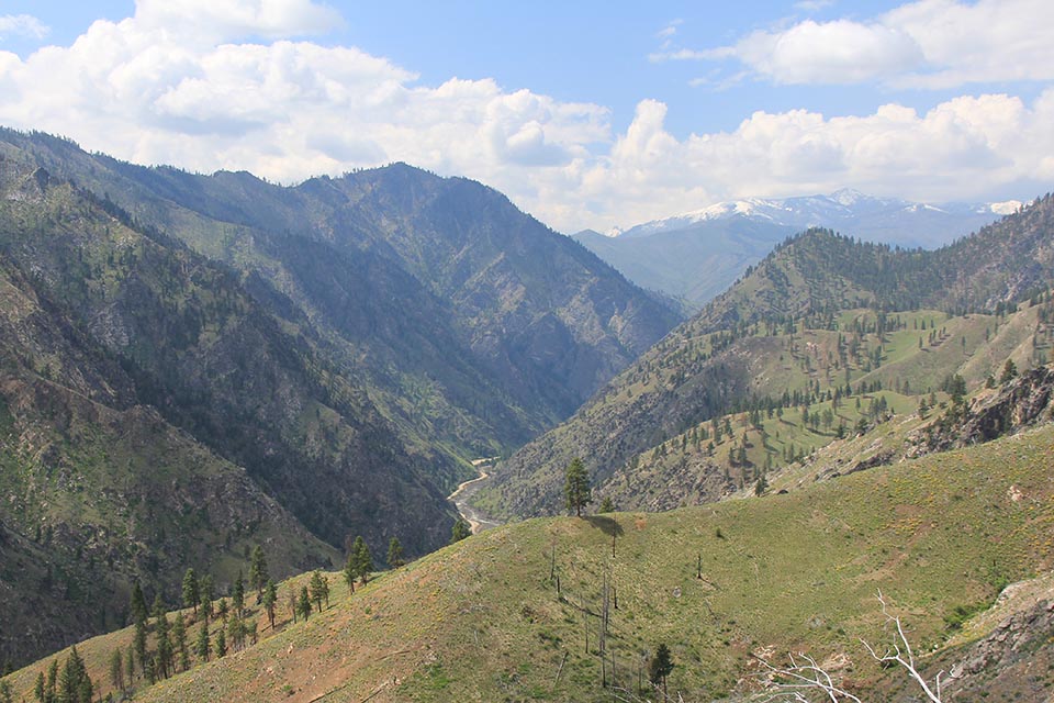
Looking west down the canyon of the Salmon River from about 3 km northwest of Shoup, Idaho in 1910 (Joseph B. Umpleby, USGS-ujb00005) and in May, 2016 (CW-2016-05-10-0068). Partially due to the high use by native peoples fishing along the river prior to the 1900s, the valley sides were frequently burned, usually with low intensity fires. This created open stands of mature ponderosa pine. After several decades of fire suppression, a series of higher intensity fires after 1990 killed many of these older trees. A narrow gravel road now clings to the left river bank.
August, 1805: Lewis and Clark Meet the Shoshone on the Salmon River
On Sunday, August 11, 1805 Captain Lewis was on the headwaters of the Beaverhead River. He and three others hiked westwards along a Shoshone trail leading towards today’s Lemhi Pass on the Continental Divide. They were desperately looking for native peoples to buy horses for their expedition. Finally the expedition saw a member of the Shoshone tribe:
I discovered an Indian on horse back about two miles distance coming down the plain toward us. with my glass I discovered from his dress that he was of a different nation from any that we had yet seen, and was satisfyed of his being a Sosone; his arms were a bow and quiver of arrows, and was mounted on an eligant horse without a saddle, and a small string which was attatched to the underjaw of the horse which answered as a bridle. I was overjoyed at the sight of this stranger… (Lewis, Sunday August 11, 1805).1
Although the lone Indian rider quickly escaped to the west, Lewis followed the trail across the pass, and over the next weeks encountered several hundred Shoshone people on the on the headwaters of the Pacific-bound Salmon River:
I afterwards understood that the Indians we had first seen this morning had returned and allarmed the camp; these men had come out armed…expecting to meet with their enemies the Minetares of Fort de Prarie whome they Call Pâh’-kees… they were armed with b[o]ws arrow and Shield except three whom I observed with small pieces such as the N. W. Company furnish the naives with which they had obtained from the Rocky Mountain Indians on the yellow stone river with whom they are at peace. (Lewis, Tuesday August 13, 1805).2
These were Lemhi Shoshones, a division of the Northern Shoshones of the Rocky Mountains, known to the Great Plains tribes as “Snakes” or “Grass Lodges.” These northern Shoshones had, by the early 1700s, acquired horses, began increased their territory northeastwards, and developed a mixed economy based upon hunting bison on the plains and foothills of the eastern slopes, and roots and salmon in western slope mountain valleys. By 1805, they were be pushed back south by the Blackfoot and other tribes that now possessed both horses and guns.3
Later, in his journal, Lewis provided further details on their annual round:
“from the middle of May to the firt of September these people reside on the waters of the Columbia where they consider themselves in perfect security from their enimies as they have not as yet ever found their way to this retreat; during this season the salmon furnish the principal part of their subsistence and as this firsh either perishes or returns about the 1st of September they are compelled at this season in surch of subsistence to resort to the Missouri, in the vallies of which, there is more game even within the mountains. here they move slowly down the river in order to collect and join other bands either of their own nation or the Flatheads, and having become sufficiently strong as they conceive venture on the Eastern side of the Rockey mountains into the plains, where the buffaloe abound. but they never leave the interior of the mountains while they can obtain a scanty subsistence, and always return as soon as they have acquired a good stock of dryed meat in the plains; when this stock is consumed they venture again into the plains; thus alternately obtaining their food at the risk of their lives and retiring to the mountains, while they consume it.” (Lewis Monday August 19, 1805).4
One of the Shoshone also gave Lewis the unfortunate news that it would very difficult to follow the stream further westwards as:
“the river was confined between inacessable mountains, was very rapid and rocky insomuch that it was impossible for us to pass either by land or water down this river to the great lake where the white men lived as he had been informed.” (Lewis, Tuesday August 13, 1805).5
During the next few days, Lewis crossed back over the divide with a group of Shoshone to guide Clark and the rest of the expedition westwards. Sacajewea, the native women who helped guide the expedition up the Missouri was reunited with her brother, Cameahwait, a Shoshone chief. Partially through this fortuitous relationship, Lewis and Clark began to purchase food and horses from the local people. From this point until they reached the Clearwater River, Lewis and Clark were guided by a Shoshone possibly named “Tosa-tive koo-be”, who the captains called “Old Toby.” He had an incredible knowledge of the mountain trails, and is largely responsible for the expedition’s success. Initially, Toby took Clark on a reconnaissance down the canyon of the Salmon River to confirm that it was indeed not a potential route to the west. After passing numerous small groups of people fishing for salmon, they reached a location likely near the present Panther Creek, a few miles below present Shoup, Idaho, along the stretch of the canyon shown in the repeat photographs above. Clark recognized this was not a safe route:
“This river is about 100 yads wide and can be forded but in a few places. below my guide and maney other Indians tell me that the Mountains Close and is a perpendicular Clift on each Side, and Continues for a great distance and that the water runs with great violence from one rock to the other on each Side foaming & roreing thro rocks in every direction, So as to render the passage of any thing impossible.” (Clark, Friday August 23, 1805).6
With this knowledge, the expedition continued to buy enough Shoshone horses for an overland trip. At the end of August, Toby guided the expedition northwards on good Indian trails up the north fork of the Salmon River. The Shoshone people prepared to travel eastwards for their fall bison hunt:
This day warm and Sultrey, Praries or open Valies on fire in Several places— The Countrey is Set on fire for the purpose of Collecting the different bands, and a Band of the Flatheads to go to the Missouri where They intend passing the winter near the Buffalow (Clark, Saturday August 31, 1805).7
Toby took Lewis and Clark northwards across Lost Guide Pass into the Bitterroot Valley. From here, he knew a good trail existed through the mountains to navigable waters the Snake and Columbia rivers.
Map and Footnotes
- http://lewisandclarkjournals.unl.edu/read/?_xmlsrc=1805-08-11.xml&_xslsrc=LCstyles.xsl ↩
- http://lewisandclarkjournals.unl.edu/read/?_xmlsrc=1805-08-11.xml&_xslsrc=LCstyles.xsl ↩
- Mann, J.W.W. Sacajawea’s People: The Lemhi Shoshones and the Salmon River Country. Lincoln: University of Nebraska Press:12-14; Binnema, T. Common and Contested Ground: A Human and Environmental History of the Northwestern Plains. Norman: University of Oklahoma Press, 2001: 100-102. ↩
- http://lewisandclarkjournals.unl.edu/read/?_xmlsrc=1805-08-19.xml&_xslsrc=LCstyles.xsl ↩
- http://lewisandclarkjournals.unl.edu/read/?_xmlsrc=1805-08-13.xml&_xslsrc=LCstyles.xsl ↩
- http://lewisandclarkjournals.unl.edu/read/?_xmlsrc=1805-08-23.xml&_xslsrc=LCstyles.xsl ↩
- http://lewisandclarkjournals.unl.edu/read/?_xmlsrc=1805-08-31.xml&_xslsrc=LCstyles.xsl ↩

