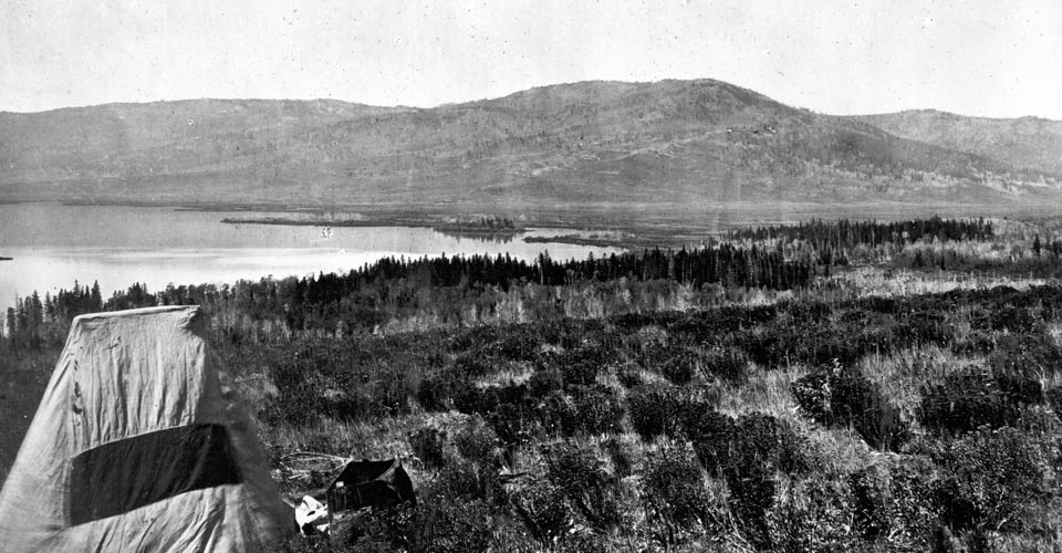
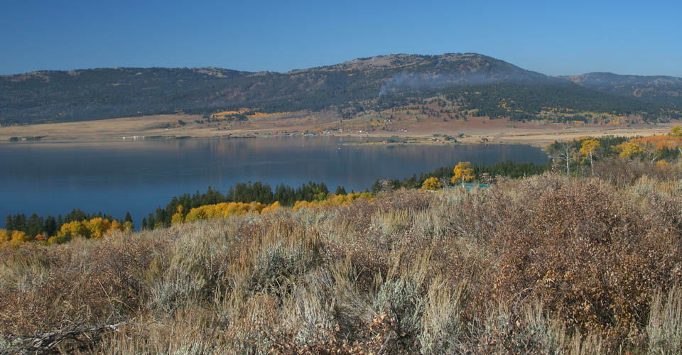
The lake level was raised by a dam constructed across the mouth of the lake in 1923, and today many recreational homes dot the slopes of the basin.1 In the fall of 2008, the Forest Service was doing a small prescribed burn on the hill in the background. Historically, these dry south facing slopes above the lake likely burned every 20-40 years, and the grasslands near the lake may have been burned every few years. Wallow-like landforms and “rub-rocks” on the western side of the lake indicate that the area may have been periodically used by bison.
Searching for a “Tip of the Finger” of Bison Dispersal near Henry’s Lake
Mary Meagher, long-time Yellowstone bison biologist, recognized that in the past small bison herds on the Yellowstone plateau were likely the “tips of the fingers” of bison dispersals from the large source populations on the Great Plains.2 Meagher’s is an apt description for the complex process by which small herds of bison periodically used mountain valleys several hundred kilometers distant from the massive herds to the east. To track these movement patterns, scientists can use data from several disciplines. In increasing resolution, these indicators include:
- Archaeology- Bones from ancient campsites and kill sites give a coarse picture of when bison and other species occupied various areas in the Snake and adjacent watersheds over time;3
- Wallow beds- Bison rolling in soft soils leave depressions that when covered with grass can persist for centuries, leaving a record of warm season occupancy. In the last few years researchers have begun to record the locations and densities of historic wallows;4
- Traditional knowledge- When available, Native Americans highly valued bison as a source of meat, robes, hides, and other products. Descriptions of bison locations and movement patterns are routinely provided in their tribal histories and accounts to early explorers;5
- Historical journals- Some early European travellers kept journals of their travels. Where these observations provide daily observations of wildlife and human sign, sightings, and kills, it provides modern researchers with an excellent description of bison abundance for the time period.6
Henry Lake may be the “tip of a finger” for a long-distance bison movement pathway over South Pass, along the route that was eventually followed by long sections of the Oregon Trail. Once these bison crossed the continental divide, they may have moved up the west side of the Rocky Mountains and the Yellowstone plateau through extensive grasslands on the headwaters of the Bear, Snake and Missouri rivers. Archaeological studies show that bison were periodic occupants of this area for thousands of years. Wallow surveys indicate that bison may have used the shores of Henry’s Lake, but to date no historic wallows have been found further east in the Madison valley or Yellowstone National Park. Native traditional knowledge obtained by Lewis and Clark from the Lemhi Shoshone was that there were few bison in this area, and that hunting parties had to travel further east on to the plains.
A detailed compilation of historical journals tell a more complex story. In the early 1800s, members of early expeditions saw only infrequent signs of bison on the upper Snake, Bear, Yellowstone and Missouri watersheds. Then, by the 1820s bison were much more abundant in this area. Hudson’s Bay Company fur trapping brigades led by Ogden, Ross, and Ermatinger routinely survived on bison meat on their “Snake River Expeditions.” Early American mountain men such as Jim Bridger and Jediah Smith also hunted bison here. Even as late as the 1830s, bison were still abundant nearby when Nathaniel Wyeth built Fort Hall near today’s Pocatello. As for the Henry’s Lake area, in October, 1839, American trapper Osborne Russell and his party obtained their winter meat supply by hunting bison on the headwaters of the Jefferson River near Red Rock Lakes. This is just one valley to the west from Henry’s Lake over a relatively low pass. However, by this time, bison numbers were again becoming low west of the mountains in the Snake and upper Missouri watersheds.7
South Pass or Bozeman Pass?
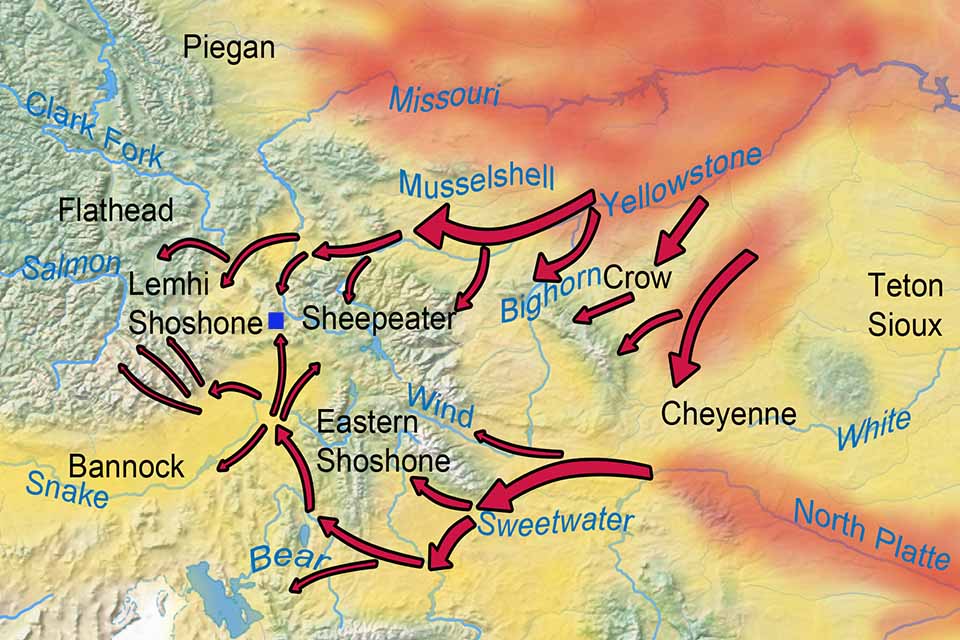
How did bison reach the Henry Lake and Red Rocks Lake area? Although the historical journals suggest that South Pass was the likely route for a dispersal event around the year 1815, it is also possible that during this or other periods bison could reach here by moving up the Yellowstone valley, crossing over Bozeman Pass between today’s Livingston and Bozeman, then dispersing into the upper Madison and Jefferson valleys. Map 1 below shows these alternate routes.
Map 1: Potential alternate movement corridors for bison to reach the upper Missouri and Henry’s Fork of the Snake watersheds (dark blue square) near today’s Red Lakes, Montana and Henry’s Lake, Idaho, showing the general territorial areas for selected Native American groups c. 1800. The southern route across the mountains would use the Sweetwater River to reach South Pass, the northern route follows the Yellowstone valley and traverses Bozeman Pass. A scenario for potential high areas of summer bison concentration is shaded in red. Areas shaded in yellow generally had very low to low bison densities. These distributions could vary annually depending on forage production and Native American hunting pressure.
One way to evaluate which travel corridor could have been most important is to use Geographic Information System (GIS) animal movement and spatial simulation techniques to evaluate the cumulative barriers to movement along these alternate routes.8 Key variables influencing bison movements could be:
- the need for large, continuous areas of relatively level terrain to maintain large herds as the bison move through landscapes with predation risk from humans and other predators. As an example of the number of hunters the bison might encounter, trapper Osborne Russell recorded for May 8 1836: “Travelled up Bear river to Thomas fork where we found …. 60 whites and nearly as many half breeds who were encamped with 400 lodges of Snakes and Bonnacks and 100 lodges lodges of Nez Perces and Flatheads.”9 This indicates that over two thousand people were in the upper Bear watershed that spring. This level of predation could eliminate herds of bison, and certainly stimulate them to move large distances.
- forage abundance and quality- bison, as with other bovids, require abundant forage to sustain growth and movement;
- sources of water- bison, similar to domestic cattle, require large amounts of water, especially during the summer when temperatures are hot, cows are lactating, and bulls are wallowing. Animals can require open water daily when there is no snow;
- landscapes with low predation risk, such as buffers zones between tribes at war.10
Researchers will likely use these variables in GIS models over the next few years to help us understand how the “tips of the fingers” were reached by bison as they entered the mountains.
Additional information:
Go to Bison Western Range Edge Overview
Go to Modern Bison Effects on Madison River in Yellowstone National Park
Map and Footnotes
- https://en.wikipedia.org/wiki/Henrys_Lake ↩
- Mary Meagher, interview with Cormack Gates, July 15, 2004 p. 66 in Gates, C. and L. Broberg. Yellowstone Bison: The Science and Management of a Migratory Wildlife Population. Missoula: University of Montana Press. 2011. ↩
- Numerous archaeological studies have evaluated the sporadic bison use of the Snake, Bear, Green, and middle Columbia river watersheds over time. These include: Plew, Mark G., and Taya Sundell. “The Archaeological Occurrence of Bison on the Snake River Plain.” North American Archaeologist 21:119-137 (2000); Lyman, R. Lee. “Late-Quaternary Diminution and Abundance of Prehistoric Bison (Bison sp.) in Eastern Washington State, USA.” Quaternary Research 62 (2004) 76–85; Grayson, D. K. “Holocene Bison in the Great Basin,Western USA,” The Holocene 16 (2006) 913-925; Plew, Mark G. “Archaic Hunter-Gatherer Diet Breadth and Prey Choice on the Snake River Plain.” Journal of Northwest Anthropology 43(2009):27-56. ↩
- White, C. A. Survey of Historic Bison Wallows: Methodology as of August 14, 2015. Technical Report. Canmore, AB: CW and Associates. ↩
- For Idaho, an important example of traditional knowledge is recorded in Lewis and Clark’s journals. On August 9, 1805, after meeting with the Lemhi Shoshone, Lewis described how there were, at that time, few bison in the upper Salmon and Snake, Missouri river areas, and thus the Shoshone annually made trips across the continental divide then down the Missouri out to the plains to hunt bison. See Lewis and Clark Journals: http://lewisandclarkjournals.unl.edu/read/?_xmlsrc=1805-08-19.xml&_xslsrc=LCstyles.xsl ↩
- The most detailed analyses of historical journal life wildife observations are: Kay, C. E. “Aboriginal Overkill: The Role of Native Americans in Structuring Western Ecosystems.” Human Nature 5 (1994): 359–98; Kay, C. E., B. Patton, and C. A. White. “Historical Wildlife Observations in the Canadian Rockies: Implications for Ecological Integrity.” Canadian Field Naturalist 114 (2000): 561–83; Kay, C. E., “Were Native People Keystone Predators? A Continuous-Time Analysis of Wildlife Observations Made by Lewis and Clark”. Canadian Field-Naturalist 121 (2007): 1-16. ↩
- Kay, “Aboriginal Overkill”; Kay “Lewis and Clark” Haines, A. L., ed. Journal of a Trapper: Osborne Russell. Lincoln: University of Nebraska Press, 1955. Bison Book edition, 1965; Bison abundance trends over time is from an analysis of first person journal observations, Cliff White in progress. ↩
- For an example of using this technique to simulate bison movements see: Gates, C. and L. Broberg. Yellowstone Bison: The Science and Management of a Migratory Wildlife Population. Missoula: University of Montana Press. 2011; Gates, C. Cormack, Brad Stelfox, Tyler Muhly, Tom Chowns and Robert J. Hudson. The Ecology of Bison Movements and Distribution in and Beyond Yellowstone National Park. Faculty of Environmental Design, Calgary, AB: University of Calgary, 2005. ↩
- Haines, Journal of a Trapper, p. 41. ↩
- Kay, “Lewis and Clark” ↩


