


The view west from the top of Old Fort Point across the confluence of the Athabasca and Miette rivers, the west edge of Jasper townsite, and up the Miette Valley towards the continental divide in 1915 (MP Bridgland, MLP e011313204), in 2019 (Mountain Legacy Project DSCF3811) and in the fall of 2024 after the July wildfire (CW-2024-10-iphone-2843).
The historic fire regime of frequent fires in the valley bottoms maintained the relatively open meadow and shrub conditions visible in the 1915 image. Removal of Indigenous people and aggressive fire suppression to protect the town allowed lodgepole pine and spruce forests to spread across meadows and thicken. In addition, high densities of elk in valley bottoms gradually removed aspen and willow thickets in many areas near the town. In the late 1990s mountain pine beetle attacked mature pine trees, and by the time of 2019 image this further increased biomass available for burning. The general pattern of biomass increase is like the aging forests in Banff National Park after ~CE 1900 which favor high intensity fires during droughty summers.
The deep black char in the 2024 photograph indicates the intensity of the late July, early August 2024 Athabasca valley wildfire as it advanced north on the afternoon of July 24 towards the town (from the left to right of the above image).
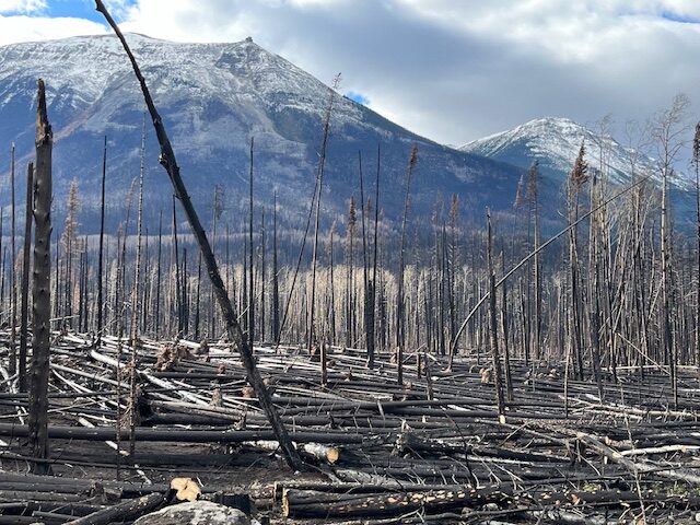
Near the junction of Highway 16 and the Icefields Parkway live standing trees, fallen timber and soils were hotly incinerated.
Perhaps due to fuel breaks or confluence of valley-winds near the town, the massive convection column that was lofting burning gases and fuels into the upper atmosphere earlier in the day collapsed at 5:45 pm, and a surface southwest wind began to spread embers into the town. The high density of the forest immediately upwind continued to provide super-abundant sources to the ember-shower that landed on many of the town’s yards and buildings over the next few hours, taxing fire fighters to the maximum– but amazingly, due to detailed and rehearsed pre-planning, thousands of people from the town and region had been safely evacuated, and eventually over two-thirds of the town’s buildings were saved. Unfortunately the nearby fire sent a massive ember shower into the western edge of the town.
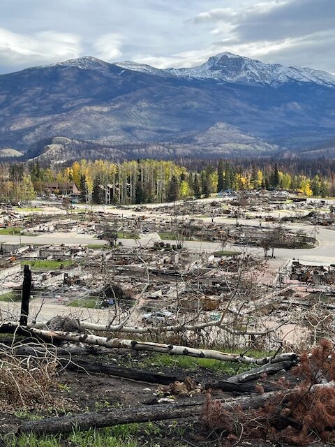
Cabin Creek, the subdivision closest to the intense fire (visible on the far right of the view from Old Fort Point) was largely destroyed. Old Fort Point is visible in the left mid-ground.
Banff, Jasper’s sister-town to the south faces a similar fate and can hopefully learn from the tragedy.
References
Satya Inc. 2025. The 2024 Jasper Wildfire Complex Municipal After-Action Review. Prepared for Municipality of Jasper. Jasper, AB.