

The summit of the Eldon Hill along the Banff-Lake Louise road in the 1930s (Glenbow Museum NA-3379-13) and the Bow Valley Parkway in 2021 (CW-2021-10-08-5064). The route of the old road is overgrown with a lodgepole pine forest and intersects the current road from the left just behind the vehicle in the photograph. Locating this spot was a rephotography challenge (see bottom of post).
Much of the Bow Valley was on a 50-100 year fire cycle for the 5-century period prior to the 1930s, resulting in a patchy habitat of young lodgepole pine and small meadows and shrublands. Most burns were lit by Indigenous people during relatively cool and moist conditions. Today, like many other areas in the Canadian Rocky Mountains, this region is on a fire cycle of >500 years. Removing Indigenous people’s burning patterns, and suppressing all fires while they are small is creating large areas of aged lodgepole pine. These old, continuous and dense forests are susceptible to mountain pine beetle infestations that create high fuel biomass as dead trees fall to the forest floor. Eventually, during a year of drought, a small fire will escape initial attack during extreme, mid-summer burning conditions, and the landscape will experience a unique, but not unexpected event-– a valley-wide conflagration from a large and intense wildfire.
Fire and biomass in Banff’s Bow Valley
From 1979 to 1983 a group of us wardens and techs had the assignment to inventory Banff’s forest biomass and fire history, and cross reference this to the maps of ongoing Ecological Land Classification for the park. This took many hard days of crawling around on our hands and knees measuring twigs, moss, and duff (a forester’s term). As per the graph below, after a bunch of number crunching, we recognized 4 broad categories of forests and their long-term patterns of burning.
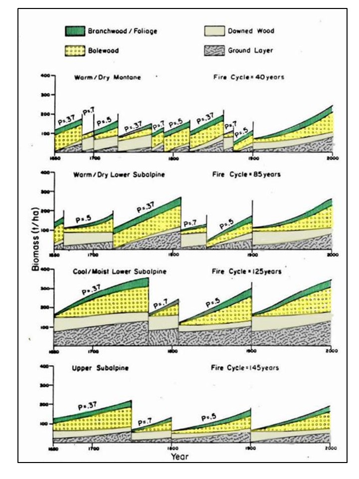
Probabilities of burning by length of period, and biomass accumulation for Banff National Park forests (from White 1985).
Warm-dry montane– Indigenous peoples frequently ignited the dry warm forests near Banff townsite, maintaining an average fire cycle of about 40 years). This routine burning often left residual patches of Douglas-fir and aspen trees, interspersed with meadows.
Warm-dry lower subalpine– These are the dry west facing forests along the Bow Valley Parkway, usually dominated by lodgepole pine. In the past they burned lon average about at 85 years, with about 2/3 of the time less than this, and 1/3 at longer intervals. As shown in the repeat photographs above, burns were often hot, but patchy.
Cool-moist lower subalpine– These forests are on the north and east facing slopes of the valley, above the Trans Canada Highway. The average long-term fire frequency is longer (125 years), and these burns were usually large confragrations during dry years. As they age, cool-moist subalpine forests become dominated by spruce and fir, and can attain the greatest biomass of the park’s forests, but historically the fire frequency still favoured large areas of lodgepole pine.
Upper subalpine– Forests near treeline usually have patchy, long fire frequencies. Biomass accumulation is slow.
A rephotography challenge
Relocating the old photograph was a 3-decade project made difficult by the ridgeline of Castle Mountain not being visible, and deceptively, given the lay of the Rockies, there is an illusion that the cars were going in a south-eastward direction whereas the old road makes a sharp bend here, and the motorists were actually headed northwest towards Lake Louise. After many years of looking at the old photo, passing through the Bow Valley area nearly every week, and unconsciously mentally-registering the pattern of the washes and scree slopes in the background, seeing the old, un-located photograph in my files was becoming an irritation. However familiar the scene, the location could actually have been anywhere between Jasper and Crowsnest Pass. Also, given the open-vegetation cover, it seemed that the road might even be along the base of the eastern front of the Rockies. Finally, in desperation, I started plotting out the actual years that the governments of Canada and Alberta built and then paved roads. While looking at an old road map for the Bow Valley, the photograph’s potential location finally “clicked”, and on a nice day in September, 2021, after a bit of field work, this minor mystery was finally solved.
References:
White, C.A. 1985. Fire and biomass in Banff National Park closed forests. M.Sc. Thesis. Colorado State University. Fort Collins, CO.