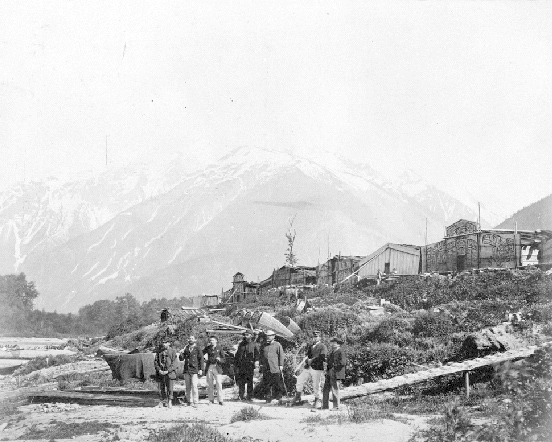
Nuxalt village at Bella Coola in June, 1870 by Frederick Dally (BC Archives). A repeat photograph is required.
July, 1793: Alexander Mackenzie Reaches the Pacific Ocean
On Wednesday, July 17 Alexander Mackenzie reached a high alpine pass through the Coast Range. His group had been trekking westwards for nearly 2 weeks though meadows along the “West Road” River, and ascending into the pine and spruce forests of on the eastern slopes of the coast range. Periodically, they encountered small groups of people, likely the Tsilgot’in (Chilcotin) fishing the streams and lakes. They hired locals to guide them through the complex network of trails. After crossing the pass, the group then began the nearly 2000m steep descent to a native village on the shores of the Atnarko River that flows towards Bella Coola. The villagers were Nuxalt (Bella Coola), a Salish-speaking nation. The next day, the village chief provided canoes and steersmen to take the expedition downstream to a larger community:
We continued our voyage, passing many canoes on the river, some with people in them, and others empty. We proceeded at a very great rate for about two hours and a half, when we were informed that we must land, as the village was only at a short distance. I had imagined that the Canadians who accompanied me were the most expert canoe-men in the world, but they are very inferior to these people, as they themselves acknowledged, in conducting those vessels. 1
Upon speaking with the chief at this next village, Mackenzie immediately learned of the long-distances travelled along the ocean inlets and straits by these peoples:
I went to take the dimensions of his large canoe, in which, it was signified to me, that about ten winters ago he went a considerable distance toward the mid-day sun, with forty of his people, when he saw two large vessels full of such men as myself, by whom he was kindly received: they were, he said, the first white people he had seen. They were probably the ships commanded by Captain Cook. This canoe was built of cedar, was forty-five feet long, four feet wide, and three feet and a half in depth. It was painted black and decorated with white figures of fish of different kinds. The gunwale, fore and aft, was inlaid with the teeth of the sea-otter. 2
On Saturday, July 20, they completed their downstream run to the ocean inlet at today’s site of Bella Coola. Mackenzie’s journal had for the last 3 days been full of comments of the large number of native peoples in this valley, and although they had been very generous in providing food and transportation, there had also had also been cases of fear and animosity. He remarked on their perilous state: “Our stock was, at this time, reduced to twenty pounds weight of pemmican, fifteen pounds of rice, and six pounds of flour, among ten half-starved men, in a leaky vessel, and on a barbarous coast.” 3 His group continued down the inlet towards the open sea only another few kilometers before turning around to begin the long trip back over the mountains, and on to Fort Chipewyan. On a rock near the water, they engraved a record near their venture: “Alex Mackenzie from Canada by land 22d July 1793.”
Astoundingly, Mackenzie’s arrival on the inlet in July, 1793 was only 48 days after it had been charted, and named “Bentinck Arm” on British maps by George Vancouver’s expedition. It is another of the northwest’s great historical coincidences that Mackenzie and Vancouver had both left distant England over 2 years previously, approached the northwest coast from two different directions, by land and sea, and had almost met in narrow mountainous fjord of which neither of them had any previous knowledge. Both expeditions encountered numerous groups of native peoples willing to trade for furs, and helped fill many blank places on the European maps, including details on the mouth of the Columbia River. However, a workable transportation route for the fur trade was yet to be found. This would eventually be resolved by the future mapping forays of the North West Company’s David Thompson and Simon Fraser, and the American government’s Lewis and Clark expedition.
<Previous page Chapter Outline Next Chapter (when ready)>
Map and Footnotes
