
Spreading Creek Wildfire, Banff National Park, July 12, 2014
BLOW-UP FIRE POTENTIAL, BOW VALLEY, BANFF NATIONAL PARK
Mark Heathcott
February, 2026
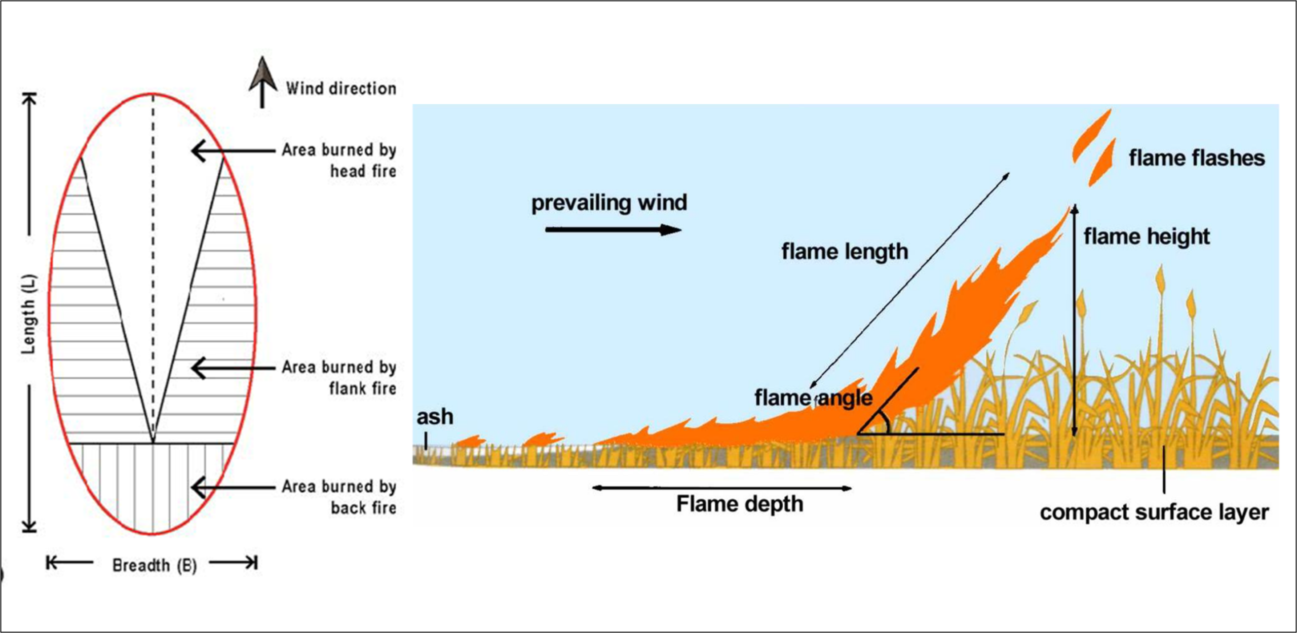
Blow-up wildfires in coniferous forests are full crown fires, consuming most of if not all (≥90%) of the conifer foliage. They spread rapidly with the wind and slope, covering many kilometres in a single afternoon/evening burning period. Suppression actions at the head of the fire where the intensity of a blow-up fire is greatest and the flame lengths the longest, is unsafe and futile even with airtankers. On level ground, fire spreads as an ellipse, with the most intense fire at the head, more moderate intensity on the flanks, and the least intense fire at the back. The spread mechanism controlling both the direction and rate of spread is wind. In rough terrain, slope also interacts with the wind to control the fire spread, with fire tending to spread uphill. Steep slopes in alignment with wind enhance spread rates the most. When the wind is downslope, it acts to dampen spread rates.
The Canadian Forest Fire Danger Rating System was used determine blow-up fire potential at Banff. The System, developed over a century of research, is used by all Canadian wildfire agencies and has been successfully adopted internationally. It tracks fuel moisture and fire spread potential in ground, surface and aerial fuels. It requires daily monitoring of noon (LST) temperature, relative humidity, wind and the previous 24hr accumulated precipitation. When combined with specific fuel types, topographic features (slope angle, slope aspect) and hourly wind, refined fire behaviour predictions are possible.
This assessment of blow-up fire potential used a mature Lodgepole pine stand with an average crown base height of 8 metres as the representative fuel type. This is a dominant fuel in montane and lower subalpine forest of Banff, and is usually found over grass/forbs on warmer/drier sites and over feathermoss on cooler/moister sites. Spruce/fir forest is the other dominant fuel on cooler/moister sites in the lower subalpine. Prediction of blow-up fires in these stands is not included in this analysis; however, given similar fuel moisture and spread potential, fire intensity is greater in spruce/fir forests.
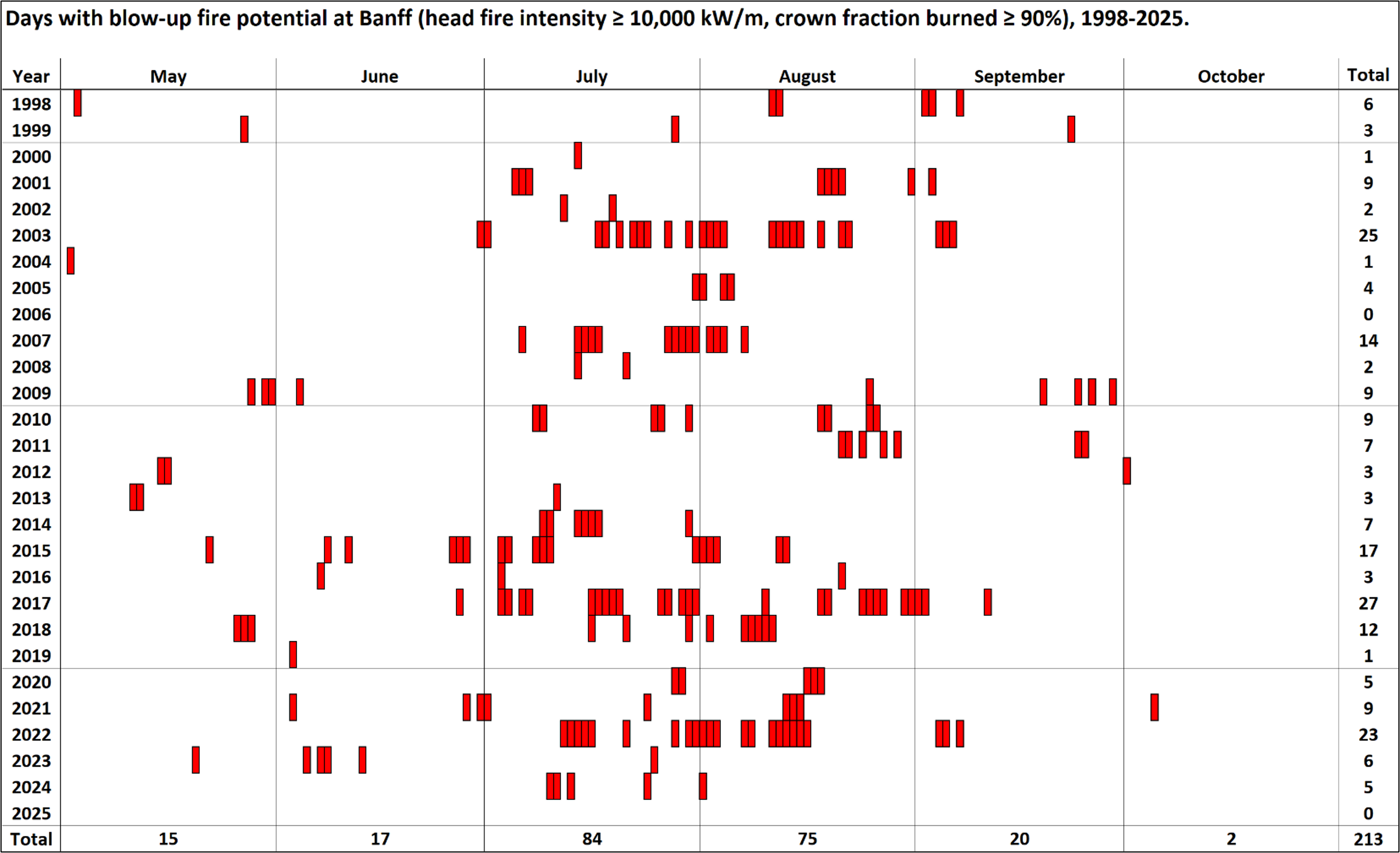
For simplicity, the topography was assumed to be flat, with wind alone the driver of fire spread. The meteorological observations necessary for calculating fire danger are generally available since 1998 for the meteorological monitoring station Banff CS (https://climate.weather.gc.ca/ or https://acis.alberta.ca/weather-data-viewer.jsp). The daily fire danger was calculated for each of the 28 fire seasons. This daily fire danger, although calculated using 1200 (LST) weather, is intended to be representative of peak burning conditions at 1600 (LST) in the afternoon of that same day. Using the lodgepole pine fuel type and the daily fire danger conditions, days when a peak head fire intensity of ≥ 10,000 kW/m (i.e., blow-up conditions) were identified. Then the predicted fire behaviour for these days was refined using hourly inputs temperature, RH, wind speed, and precipitation. There were 213 days in the 28-year record with one of more hours spread with blow-up fire conditions (i.e., a head fire intensity of ≥ 10,000 kW/m and ≥ 90% crown fuel consumption). This accounts for just over 4% of all days in the May-October fire seasons annually since 1998 although some years can have just a few days while other years can have over 25.
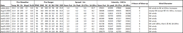
Blow-up wildfires are characterized by rapidly spreading crown fires, with the fastest predicted hourly rate of spread being 69 m/min or about 4 km/hr on August 13, 2003 at 1600hrs. Full crown fires often produce large amounts of burning embers that can ignite spot fires more than 2 km ahead of the main fire. The is also extreme turbulence and fire whirls, occasionally underneath a towering smoke column which can become a pyrocumulonimbus clouds, complete with rotation and lightning spawning new fires kilometres from the firestorm. Needless to say, attempts at head fire attack on a blow-up fire is not possible until burning conditions ease. The spread of an intense crown fire can however, be influenced and sometimes even stopped when they run into areas where fuels are non-existent (e.g., rock outcrops) or scant, best created with frequently repeated prescribed (broadcast) burns. Besides bare or charred ground, leafed-out aspen stands are resistant to spreading crown fires, as is green grass. Cured grass, slash, leafless aspen, immature conifers, and mature conifer stands with low crown base heights are extremely flammable and produce higher rates of spread and/or intensities than mature Lodgepole pine with an 8m crown base height at moderate to high fire dangers conditions. Steep slopes, especially when they are in alignment with the wind, increase rates of spread and head fire intensity. Aspect also affects fuel moisture, with south facing slopes drier and north facing slopes moister. The picture painted by the above figure is thus quite conservative, as it uses the least explosive conifer fuel type and doesn’t account for increased fire behaviour due to topography.
Ten of the worst blow-up fire days in the 28-year record are shown below. They are all characterized by extreme fire danger with peak afternoon spread of between 3.5 to 5.5 kilometres in 3 hours. The worst day, July 4, 2015, was atypical, as the wind switched from SW to NE at 1500, and remained NE to 1900. An examination of hourly wind directions in the afternoon and evening (1200-1900 hrs) for all 213 blow-up fire days, shows winds W-to-SW nearly 88% of the time, NW-to-NE 8%, and E-to-S 4%. August 13, 2003 was also atypical, when at 1600, the wind switched from SW to NE for 1 hour, and blew a fresh breeze, creating the highest 1 hour rate of spread of about 4 kilometres in an hour. The wind switched back to SW at 1700.
The Bow Valley’s wind regime remains questionable, especially as the valley orientation is NW-SE upstream of town, W-E through town, and then back to NW-SE downstream to the park gate and Canmore. The new weather station at Canmore, as well as the existing stations at Lake Louise and Bow Valley could help clarify general flow patterns, which are likely dominated by down valley winds.
Fire mitigation activities in advance of blow-up fires, with a focus on frequent large prescribed (broadcast) burns, must take into account the potential rate of spread and spotting distances during peak afternoon burning conditions. An intensive treatment zone of 5 to 6 km around the townsite is needed as a blow-up fire within this zone could reach town in three hours or less, which precludes any real chance at complete evacuation of the town and its local environs. The long-term goal for fuel management within this zone should be to convert the Lodgepole pine and spruce/fir forests to grass and aspen forests, which would provide protection during the summer months. Where this is not likely or possible, such as on cool/moist aspects, a combination of mechanical fuel manipulation and frequent broadcast burns could be used to greatly reduce or eliminate crown fire potential. Pine barrens, with scattered veterans would be an ideal landscape as well, readily treated frequently with light surface broadcast burns.
Success with this type of fuels management strategy would still leave the spring and fall periods with extensive cured grass and leafless aspen. In these “shoulder seasons” fuels could be managed with frequent broadcast burns, beginning with the first snowmelt, and then following snowmelt with surface fire on the most easily burned sites first and most often, which includes the southwest facing slopes, in alignment with the sun and the wind. Curing in the fall would also see a flurry of broadcast burning operations. Overall, this would result in the intensive zone having a very short fire cycle (similar to pre-European settlement), with some areas being burned whenever they could support a spreading prescribed fire, and others only once or twice in a 1-25-year time frame, dependent on the relative risk they pose and their flammability. Invasive species, wildlife and smoke management will also be a necessary focus. High ungulate populations could preclude any chance of restoring aspen forests around town and their numbers would have to be carefully managed, especially as repeated broadcast burns would increase the carrying capacity.
Upwind of the intensive zone (approximated by the possibility of townsite encroachment in 3 hours or less) is a somewhat less critical extensive zone. However, it is apparent consecutive days with blow-up fire potential is a regular feature of Banff’s fire environment. Three or more (maximum 6) consecutive days of blow-up fire conditions have occurred 24 times since 1998. Control of blow-up fires seldom happens overnight except in the event of rain. When the next day is as bad or worse than the preceding day, multi-day blow-up fire events handcuff suppression resources, quickly overrunning fireline installed overnight, endangering firefighters, burning up their gear and creating chaos. Having a wildfire spread into town from 25 kilometres away is a distinct possibility when examining historical blow-up fire potential. For 15 of these critical fire periods, winds remained steady out of the SW, while for 7 of them, winds switched to NE for the final day. During 2 of the critical periods, they started with NE winds, switching to SW in the following days. In narrow mountain valleys these frontal shift from SW to NE wind directions, often accompanied by rain, helped contain some historic fires.
This larger landscape also requires management using repeated broadcast burns, especially at the boundaries of natural burning blocks like those formed by ridges, changes in aspect, and the river. The ideal fire cycle in this larger extensive zone would be in the 25–75-year range, again with some locations burning multiple times while others only burn once or twice. The extent of broadcast burning and fire cycles proposed here actually reflects long terms fire cycles in Banff’s montane and subalpine forests. Restoration of the park fire regime though broadcast burning will also enhance fire protection. (This analysis done by Mark Heathcott, March, 2026).
Return to Fire Weather Overview page
References
For those individuals wishing to learn more about fire danger and fire behaviour prediction using the Canadian models visit https://cwfis.cfs.nrcan.gc.ca/background and/or review this short list of the essential documents:
- Canadian Forestry Service. 1984. Tables for the Canadian Forest Fire Weather Index System. 4th Environment Canada, Canadian Forestry Service, Ottawa, Ontario. Forestry Technical Report 25. 48p
- Van Wagner CE and Pickett TL. Equations and FORTRAN program for the Canadian Forest Fire Weather Index System. Government of Canada, Canadian Forestry Service, Ottawa, Ontario. Forestry Technical Report 33. 18p
- Van Wagner CE. Structure and development of the Canadian Forest Fire Weather Index System. Government of Canada, Canadian Forestry Service, Ottawa, Ontario. Forestry Technical Report 35. 37p
- Forestry Canada Fire Danger Group. 1992. Development and structure of the Canadian Forest Fire Behaviour Prediction System. Forestry Canada, Ottawa, Ontario. Information Report ST-X-3. 63p
- Taylor SW, Pike RG, Alexander ME. A field guide to the Canadian Forest Fire Behaviour (FBP) System. Natural Resources Canada, Canadian Forest Service, Northern Forestry Centre, Edmonton, Alberta. Special Report 11. 60p
- Lawson BD and Armitage OB. Weather guide for the Canadian Fire Danger Rating System. Natural Resources Canada, Canadian Forest Service, Northern Forestry Centre, Edmonton, Alberta. 73p
- Wotton BM, Alexander ME, Taylor SW. 2009. Updates and revisions to the 1992 Canadian Forest Fire Behaviour Prediction System. Natural Resources Canada, Canadian Forest Service, Great Lakes Forestry Centre, Sault Ste. Marie, Ontario. Information Report GLC-X-10E. 45p
To predict fire behaviour, use the field guide listed above or the REDapp https://firegrowthmodel.ca) A daily fire danger data base is also available for Banff CS, which was used in this analysis.