
Standish Chairlift at Banff Sunshine mountain resort with pyro-cumulus clouds from Verdant Creek fire to the northwest.
Verdant Fire Overview
On July 14, 2017 the Verdant Creek Fire blew up after a lightning strike torched up an old growth spruce-fir stand. The ignition was just up-valley from the confluence of the Simpson and the Vermilion Rivers along the Kootenay Parkway (Highway 93 from Banff to Radium). Kootenay National Park fire managers have long referred to this area as “Lightning Alley”—the scene of many fire-fights over the decades, and within a few kilometers of starting points of an intense fire in 1995 that nearly destroyed the lodge at Vermilion Crossing, and the massive 2003 Kootenay Park Burn that ran northeast >30 km up the Vermilion River watershed and over several weeks reached almost to the continental divide.
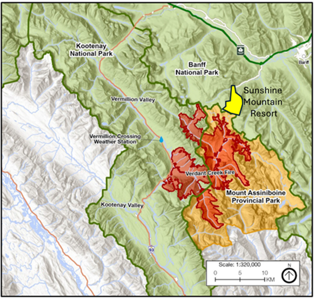
Burn area of the Verdant Creek Fire (red), Assiniboine Provincial Park (orange), national parks (green) and Sunshine mountain resort (yellow). The fire advanced northwest to within 2 km of the lease boundary. (Map from Macauley et al. 2022)
Similar to the 2003 burn, the 2017 Verdant Creek fire ran eastwards but this time up the Simpson River watershed. The conflagration burned 160 square km before being contained largely by the treeless ridges on the continental divide near Sunshine resort by September 8 (Macauley et al. 2022).
Verdant Creek Fire Behaviour
The burn was typical of modern large mid-summer lightning-ignited fire in subalpine forests. The summer of 2017 was the dryest summer since the 1970s and 2003. Lightning hit an old growth forest in a remote valley several kilometers from the highway, and explosive fire behavior occurred almost immediately. Under moister conditions the fire would have smoldered for a day or two, and in modern times could have been suppressed upon detection. Historically, even in a moist summer a smoldering fire might make some small runs, creating a mosaic of forest ages. However, today it is extreme behavior fires in dry years like the 2017 Verdant Fire that escape suppression in mid-summer and burn large areas. This sets the stage for future large area fires either in the deadfall from the immediate burn, or later in the widespread even-aged areas of regrowth.
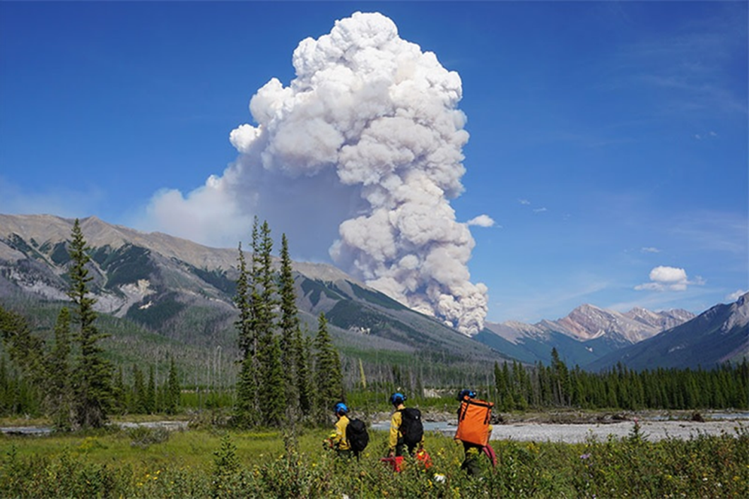
The Verdant Creek Fire blows-up in the Simpson River watershed. Note past burns in the foreground in “Lightning Alley”. On most high fire danger days, the fire appears to have had southwest winds (as shown above) generally advancing eastward towards the continental divide and Banff’s Sunshine resort. It also eventually “backed” westwards down valley to the photographer’s location near Simpson’s Viewpoint on the Kootenay Parkway, requiring periodic highway closures.
Given fire intensity, direct attack of the fire’s edge immediately after the July 14 ignition was impossible, so Parks Canada began an indirect containment strategy of holding the fire on ridges and building fire lines in forested areas where necessary to block spread over the continental divide. Eventually the fire would advance out of Verdant Creek go on to burn over 25% of nearby Assiniboine Provincial Park’s forested area.
Fire Growth Pattern
Keira Macauley and co-researchers (2022) describe how over the course of >60 days, fire growth occurred over three periods in cycles of small rainstorms followed by hot/dry weather, and periods of high winds. Parks and protected areas are some of the few areas in southern North America where this type of long-term variable fire behavior can be observed. In most settled areas they are aggressively and totally suppressed.
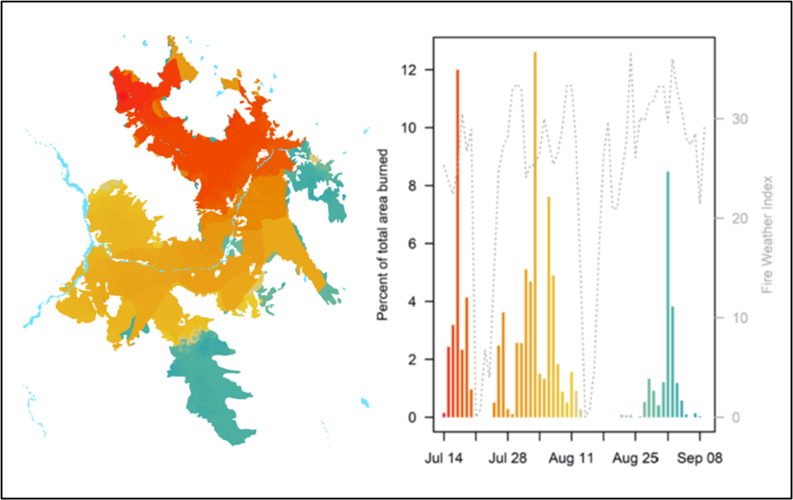
Verdant Creek Fire area mapped into three burning periods with burned area by day (from Macauley et al. 2022). Red indicates first period of burning, orange the second, and third with green.
Remarkably, a large portion of the fire growth was towards the southwest, against what is commonly thought of as the prevailing winds during high fire danger days—southwest winds drawing up hot dry air from the dry northwest Palouse prairies and Oregon deserts (Baker 1984). Possibly some of this backing behavior occurred due to burn out operations attempting to contain the western edge of the fire. Wind direction data is not presented in the analysis of fire behavior.
Impacts to Sunshine Resort, Mount Assiniboine Lodge and Bow Valley Communities
Even a fire in a remote area like Verdant Creek and the Simpson River caused major impacts to human use, safety and economics including:
- Direct high costs. For example, on August 2, Parks Canada reported that the fire was being managed with about 60 firefighters and 10 helicopters.
- Closures to commercial operations including Sunshine, Assiniboine Lodge and Shadow Lake, some of these extending to weeks. At Sunshine this was partially offset by accommodating fire crews in the hotel.
- Periodic closures to the Kootenay Parkway due to low visiblility (cold air drainage drawing smoke at night down valley to the west), and direct fire impingement during the second period of burning;
- Public air quality warnings for Banff and Canmore due to smoke reaching the Bow Valley on many days;
- Likely some decline of tourism visits to the area due to air quality, closures, or highway closures.
- Public air quality warnings for Banff and Canmore due to smoke reaching the Bow Valley on many days.
- Likely some decline of tourism visits to the area due to air quality, closures, or highway closures.
View of Verdant Creek Fire from the observation deck on top of Standish Chairlift as the burn ran up the backside of Quartz Ridge. Rock Isle Lake in midground. In general the fire perimeter on the downwind (SE, E, and NE sides) was formed by alpine terrain along the continental.
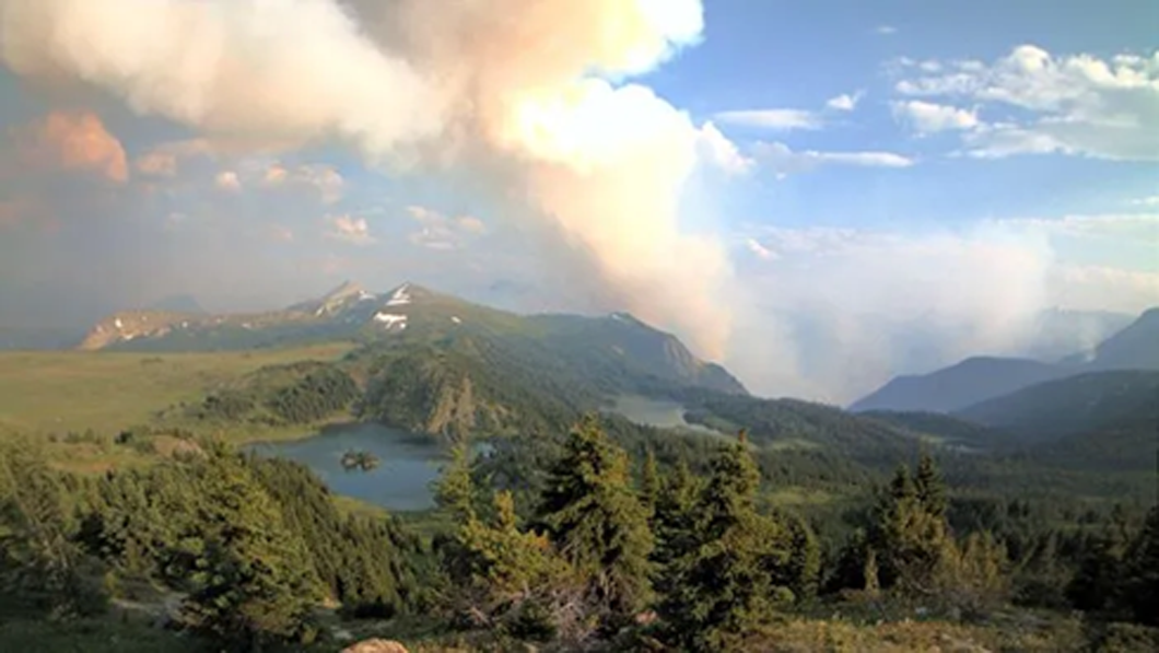
Parks Canada’s burnout and suppression operations likely important in keeping the fire from long-distance spotting into forests in Banff National Park, especially onto the headwaters of Howard Douglas, Healy, and Red Earth Creeks. Stand age and fire history observations show that fires do periodically cross the divide. For example, the 1920 Simpson River fire spotted over the divide and burned in the headwaters of Howard Douglas and Bryant creeks. The unique larch forests bordering the Sunshine Meadows or Healy Pass result from frequent historic fires in the Simpson watershed reaching the continental divide and burning upper elevation forests.
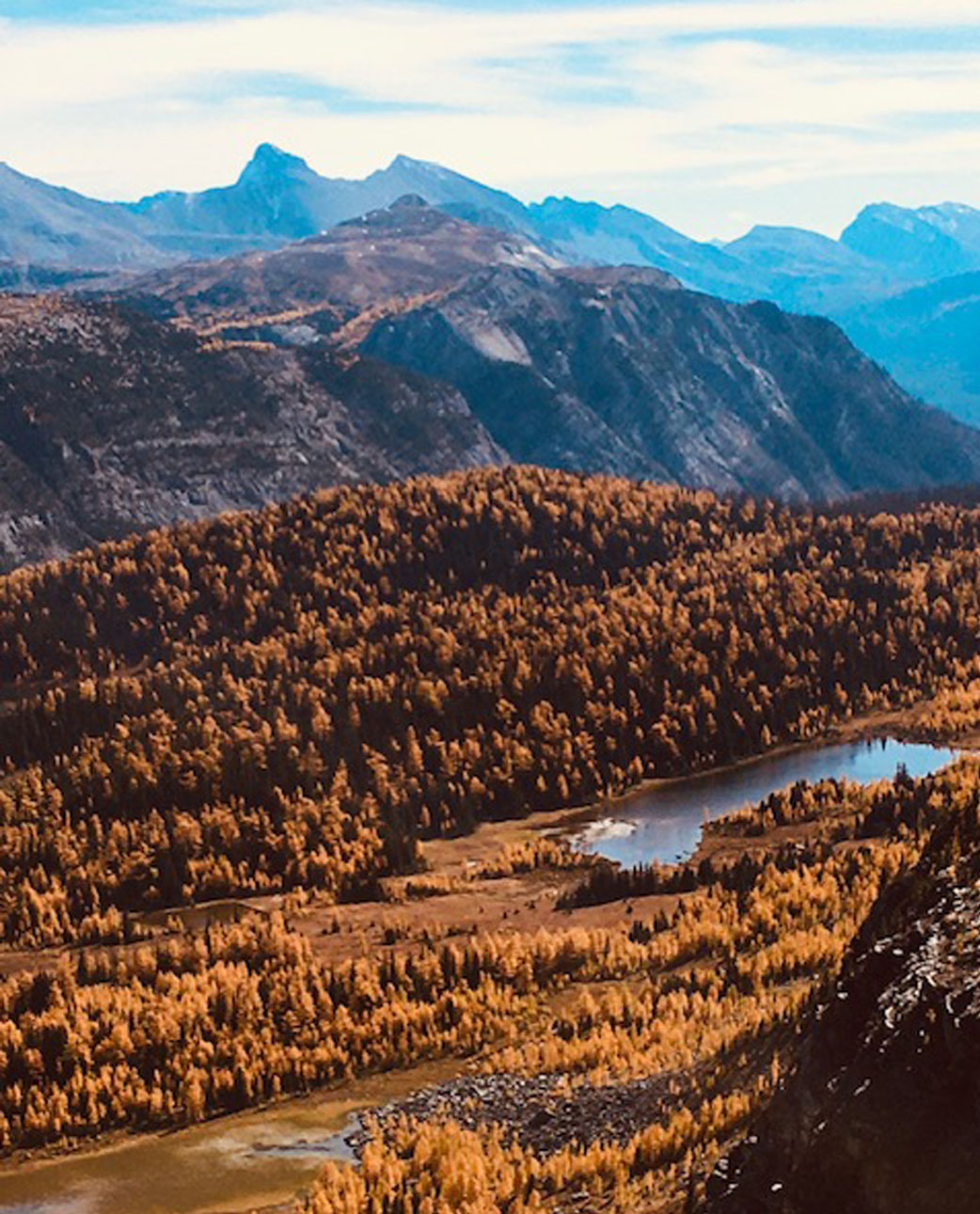
Plateau near Simpson Pass showing larch forests created by frequent past fires. In the mid-ground is a blackened area intensely burned by the 2017 fire. Alpine terrain at the top of the slope held the fire from advancing towards the Sunshine Resort.
Future Research
The future of fire management in Banff and other Rocky Mountain national parks will continue to include many opportunities to contain burns with a combination of using terrain and burnout operations. This will allow more long-term periods of burning and variability of fire behavior that can occur over many days or weeks of burning. However, this will often be achieved with burnouts where fire behavior might be much more extreme, or much less extreme than historic burning patterns. For example, in their discussion of the Verdant fire Macauley et al. describe that:
Fire intensity and associated heat transfer mechanisms are limited by changing weather conditions, by the composition, configuration, and moisture content of adjacent fuels, and by anthropogenic means such as water application to the fire’s edge during fireline construction.
To these factors we need to add the pattern and timing of ignitions done in burn out operations. This was not described for Verdant although it’s possible that a large portion of the burned area was caused by aerial strip ignitions.
Further, given that the continental divide and other high elevation areas will routinely be used to help broaden out containment lines, what will be the effects of how much tree line vegetation is removed by these fires? For example, on the Verdant Fire, likely burnouts done under controllable conditions almost certainly reduced fire spread into these high elevation forests. Will ongoing lower fire frequencies eventually reduce alpine larch cover, or in Sunshine’s case, the meadows themselves? Thus, although the higher elevations around Banff’s Sunshine may favour fire suppression that reduces risk to the infrastructure, ultimately this will reduce the scenic attraction of the resort’s landscape.


Howard Douglas Lake in the Sunshine Meadows with Mount Assiniboine in the background. In the 1900 photograph the area had been burned in the 1800s and was only slowly regenerating to forest. In the 2001 photo a warmer climate and a fire-free period have encouraged regeneration of subalpine fir and larch across the meadows. The 2017 fire reached the ridge on the right but did not burn across the meadow. (Photograph credits: Glenbow Museum and CW)
Return to Wildfire vs Mountain Resorts Overview page
References
Baker Ken A. 1984. Weather Patterns Wildland Fire in Banff National Park. Technical Report. Warden Service Parks Canada.
Macauley, Kiera A. P., Neal McLoughlin, and Jennifer L. Beverly. 2022. “Modelling Fire Perimeter Formation in the Canadian Rocky Mountains.” Forest Ecology and Management 506 (February): 119958. https://doi.org/10.1016/j.foreco.2021.119958.