
Recent patterns of burning on Banff’s Mount Norquay (May 6, 1992 prescribed fire) and Jasper’s Marmot Basin (2024 wildfire).
These areas have very different patterns of wildfire risk and potential mitigation actions. Note the extreme fire intensity of the 2024 Athabasca Valley burn as it swept below Marmot Basin. Click image to enlarge.
FIRE HISTORY AND WILDFIRE RISK FOR TWO MOUNTAIN RESORTS:
Banff’s Mount Norquay vs Jasper’s Marmot Basin
M-P Rogeau, Fire History Analyst, May 2026.
Introduction
Many similarities can be drawn between Mount Norquay and Marmot Basin ski resorts. They are both local ski hills located near mountain towns situated in national parks of the Canadian Rockies, and both areas share a similar historical past in terms of Indigenous land use, settlements and, construction of a railroad and major travel corridors. Interestingly, these similarities stop here when it comes to their wildfire history and current wildfire threat. Putting aside weather conditions and vegetation types and conditions, the physical environment of the land placement of an infrastructure in the mountains plays a significant role in wildfire survivorship probabilities. Wind direction and slope exposure, topographic position, slope angle, and main valley orientation in relation to prevailing winds are the major factors influencing such probabilities.
Wind Exposure
Both ski resort runs are mostly on the protected lee side of prevailing southwesterly and westerly winds coming from Pacific air masses. However, wind flow is highly affected by mountain topography that angles and bends winds to funnel them in the same direction as valleys. The wider the valleys, the more flow, and the more likely that valley winds will dominate over the prevailing southwesterlies.
In the Bow Valley around Banff, southwesterly and westerly winds prevail 60% of the time, winds from the south-southwest make up another 10%, while winds from other directions are far less frequent (see figure). Sustained and predictable prevailing winds from the SW make any east and north-east facing slopes generally protected from the wind, while slopes receiving direct or angled winds from the prevailing flow are highly vulnerable to burning during a wildfire. If the Banff weather station was located west of Town (by the Fenlands), it is very likely that it would capture a greater component of S and SE winds aligned with the Spray Valley, which makes a beeline towards Norquay. This makes the lower slopes of Mount Norquay, in the Bow Valley highly susceptible to high impact winds coming from a wide array of wind directions. This means that the southern slopes and access road of Mount Norquay have high fire risk, but more northern aspects are less risky.
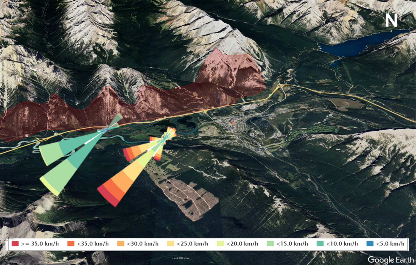
Wind rose of speeds and direction for Banff weather station at the base of Mount Norquay. The red shaded zone shows the warm-facing aspect where dry, easily ignitable fuels are found. The left windrose represents from which direction the wind blows on average and at what speed, whereas the right windrose shows the peak wind speeds. The width of the bars captures frequency of occurrence. Data source: Alberta Climate Information Services (ACIS), hourly wind data recorded between June 10, 2014 and December 31, 2025.
The Athabasca Valley south of Jasper, which flows in a S-N direction, is a good example of its influence on valley winds where south winds are slightly more dominant than southwesterlies (see figure). The Jasper Warden station (east of Town) also receives the influence of Maligne valley (SE-NW alignment) and thus captures a fair number of SSE and SE winds. This means that due to prevailing wind directions Marmot is largely protected on its upwind sides by rock and ice, but as occurred in 2024 fires will be driven downvalley at lower elevations near its base.
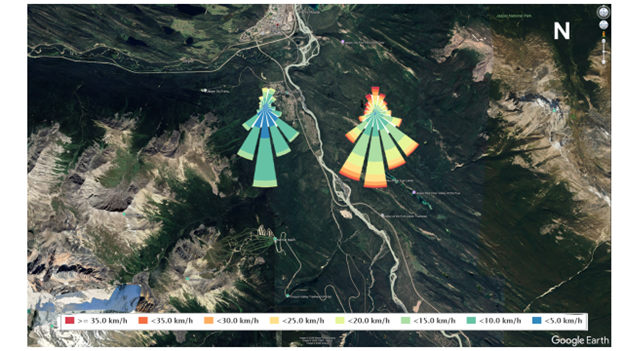
Wind rose of speeds and direction for the Jasper Warden station weather station. The left windrose represents the average hourly wind directions, whereas the right windrose shows the hourly peak wind directions. The width of the bars captures frequency of occurrence. Data source: Alberta Climate Information Services (ACIS), hourly wind data recorded between June 1, 2015 and December 31, 2025.
Topographic Elements.
Topography exerts a high degree of influence on fire spread patterns. Studies from the Canadian Rockies and other mountain settings of western North-America looked at the age of forests and evidence of historical fires over the last few centuries in relation to their topographic position. Strong patterns emerged from these studies showing the compounding effect of various topographic components on survivorship of a forest to wildfires. Among various topographic elements assessed, some of the strongest drivers of fire frequency in the Subalpine are elevation and aspect combined together, whereas elevation alone was found to be the main driver in the Montane.
For every 100 m. increase in elevation in the Montane, the chance of burning decreases by 12%, whereas in the Subalpine, this rate of decrease augments to 33%. This translates into valley bottoms being a lot more flammable than higher elevations. Further, in the Subalpine, a cool aspect (northwest to east facing slopes) is twice as likely to survive a forest fire than a warm aspect (south to west facing slopes). Taken together, forests growing at high elevations nearing treeline and on a cool aspect have exponential chances of surviving a forest fire. These elements also correspond where ski resort ski runs are located for similar reasons that aspects receiving less sun exposure can maintain lower temperatures and retain higher humidity and snow longer.
Slope Angle
The slowest rate of fire spread, without considering wind speed, is on flat terrain. In the mountains, this largely corresponds with valley bottoms. The fire spread rate increases with slope angle due to the tilting of the flames in tree crowns, which allows for faster ignition of uphill trees. Think of lighting a match and tilting it and see how much faster fingers get burned unlike keeping the match horizontal.
Valley Orientation
The lower slopes of Mount Norquay, facing the Town of Banff, are a warm aspect (south facing), which means drier vegetation that ignites more easily. This wildfire threat is compounded by both slope steepness and a valley orientation that aligns with prevailing winds, as well as valley funneled winds. In contrast, Marmot Basin is in the path of only valley funneled winds. Its cool-facing aspect combined with high elevations are powerful topographic elements that create conditions for wildfire refugia to persist through the centuries. The fierce valley winds with tornadic elements during the 2024 Jasper fire moved the fire front quickly and away from the ski resort, which was another contributing factor of survivorship.
Fire History
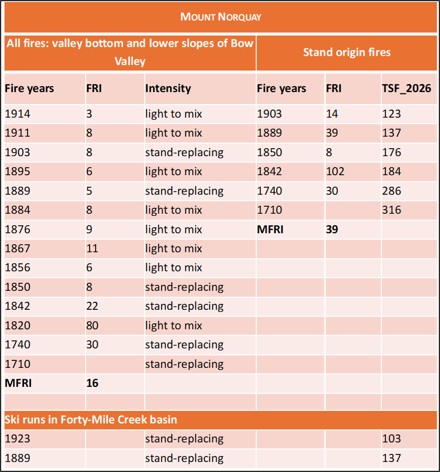
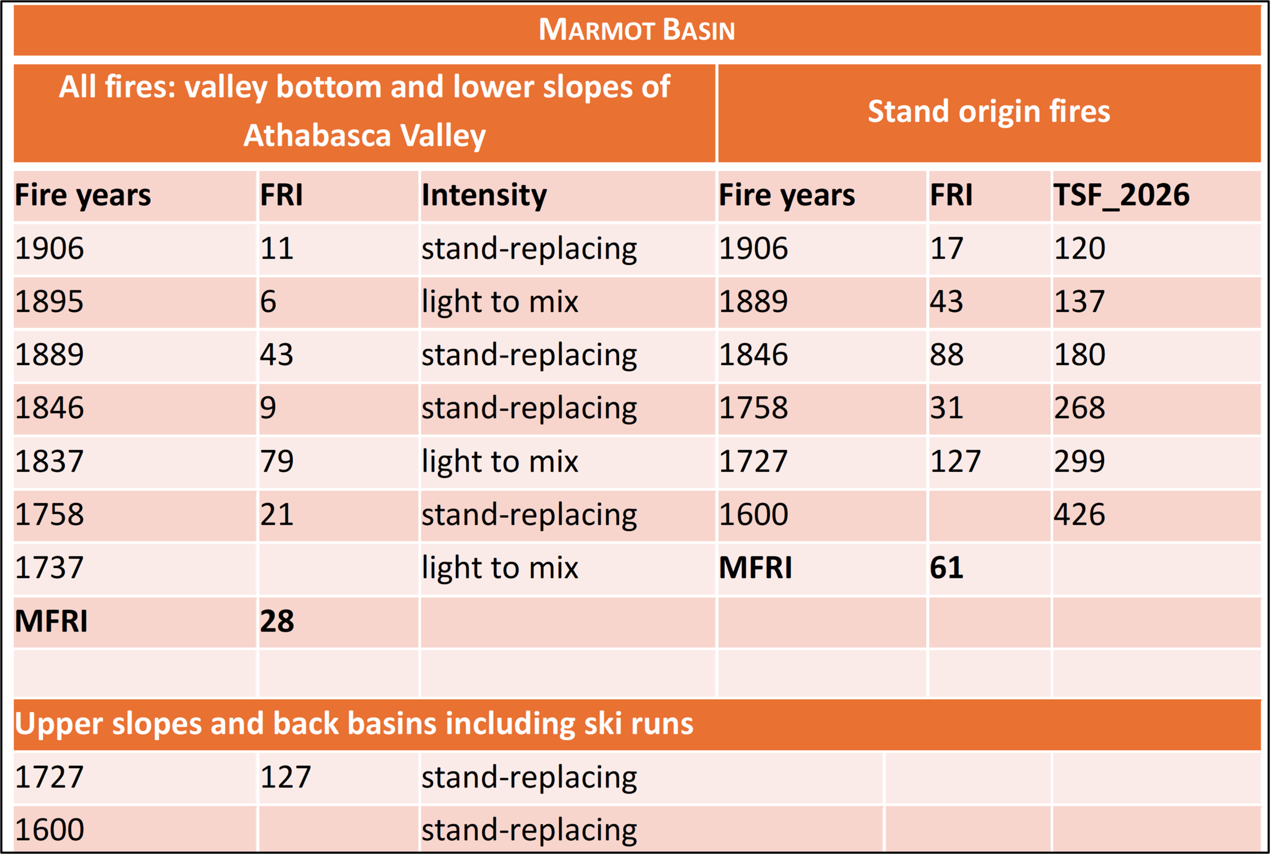
The above variables help explain different fire histories for the two resorts as determined from tree-ring counts, including the number of fires, number of years between fires (i.e. Fire Return Interval (FRI)) and mean fire return interval (MFRI) in the immediate areas. Some fires burned with lighter intensities only killing surficial fuels or thinned out patches of forests, whereas others were of greater intensities and killed most of the forest (i.e. a stand-replacing fire creating a new evenly-aged forest).
The following tables contrast the fire history differences and exemplify the powerful effect topography can have on burning probabilities. The warm lower slopes of Mount Norquay, also in the direct path of prevailing winds and valley funneled winds from the Spray, historically burned twice as often as Marmot did. The vicinity of Mount Norquay had a MFRI of 16 years when considering fires of all intensities, and a MFRI of 39 years when considering those that renewed forests. The forest surrounding Mount Norquay ski runs last burned in 1923 and 1889, with a prescribed fire bordering the area in 1992 (see image above).
In contrast, Marmot’s MFRI for all fires was 28 years, while it was 61 years for stand-replacing fires. whereas Marmot Basin’s forest last burned in 1727 and sometime prior to 1600 – 1650 (unknown) and is considered a persistent wildfire refugium. The 2024 wildfire followed the typical fire history pattern of not burning within the resort itself, but burning the powerline and access road at lower elevations (see image above).
Wildfire Risk Mitigation
The different fire risk patterns for the two resorts require different risk reduction strategies.
- Mt. Norquay- Historically frequent fires on the southern slopes of Mt. Norquay maintained vegetation types such as grasslands, aspen, and Douglas-fir/lodgepole pine savannas with low to moderate fire intensities. These vegetation types could be restored by mechanical clearing near the access road, followed by spring maintenance prescribed burns (such as shown in the 1992 image above) when natural and artificial snowpack at the resort itself limits fire spread and increasing preparedness during high fire danger periods (e.g. water systems, sprinklers, snow guns etc.).
- Marmot Basin- The infrequent burns affecting the area occur during drought years and have high intensities. Risk can be mitigated by forest clearing where required near the base of the resort and increasing preparedness during high fire danger periods (e.g. water systems, sprinklers, snow guns etc.).
These landscape level strategies must be combined with standard FireSmart protection for each resort’s infrastructure and immediate surroundings.
Return to Mountain Resorts Wildfire Risk overview page
References
Krawchuk, M.A., S.L. Haire, J. Coop, M.-A. Parisien, E. Whitman, G. Chong and C. Miller. Topographic and fire weather controls of fire refugia in forested ecosystems of northwestern North America. Ecosphere 2016, 7, e01632, doi:10.1002/ecs2.1632.
Rogeau, M-P. and G.W. Armstrong. 2017. Quantifying the effect of elevation and aspect on fire return intervals in the Canadian Rocky Mountains. Forest Ecology and Management 384: 248-261.
Rogeau, M-P., and D. Gilbride. 1994. Stand origin mapping of Banff National Park. Technical report prepared for Banff National Park, Resource Conservation Branch, Banff, AB, Canada. 70 p. + 8 map sheets.
Rogeau, M-P., Q.E. Barber and M.-A. Parisien. 2018. Effect of topography on persistent fire refugia of the Canadian Rocky Mountains. Forests 9:285.
Tande, G.F. 1977. Forest fire history around Jasper townsite, Jasper National Park, Alberta. M.Sc. Thesis, University of Alberta, Edmonton, AB, Canada.
Tande, G.F. 1979. Fire history and vegetation pattern of coniferous forests in Jasper National Park, Alberta. Can. J. Bot. 57: 1912-1931.
White, C.A. 1985a. Fire and biomass in Banff National Park closed forests. M.Sc Thesis. Colorado State University, Fort Collins, CO. U.S.A. 205 p.
White, C. 1985b. Wildland fires in Banff National Park, 1880-1980. Occasional Paper No.3. National Parks Branch, Parks Canada, Environment Canada. Catalogue No.: R61 2/8- E. 108 p.