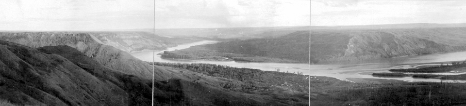
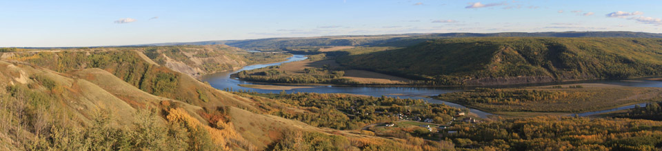
Panorama of Old Fort St. John on the Peace River in c. 1910 (BC Archives) and 2010 (CW Collection).
1792-93: Alexander Mackenzie on the Peace River
Once the central provisioning and trading post that would eventually become Fort Chipewyan was located on Athabasca Lake, the next major issue facing fur traders in northern boreal forests was to locate a shorter waterway to the ocean. For the North West Company, the annual cycle of moving furs by canoe several thousand kilometers out to Montreal, and trade goods back inland to Athabasca Lake was clearly an almost superhuman task. In addition, the Canadian “pedlars”, who did not have the charter obligations facing the Hudson’s Bay Company of taking furs only to England, recognized that excellent returns might be obtained by moving furs westward across the Pacific to China and other eastern markets. North West Company trader Peter Pond, working from the descriptions of resident peoples, made a rough map in 1785 of river routes north and west that might link to a major inlet that Captain Cook’s expedition had mapped on the northern Pacific Coast. In 1789, Alexander Mackenzie travelled downstream from Lake Athabasca on the major river that now bears his name to reach the Arctic Ocean. Mackenzie then returned to England, upgraded his navigational skills, and prepared to map an alternate route up the Peace, a great river joining the Athabasca from the west, and that local First Nations described as having its source west of the mountains, and possibly closer to Cook’s inlet. 1
In preparation for Mackenzie’s 1793 trip to map a route to the Pacific, in the fall of 1792, the North West Company established a trading and provisioning post along the Peace on the mouth of the Smokey River. Mackenzie wintered here, and on May 9, 1793 embarked for the west in a canoe of birch bark built especially for the trip:
The canoe was put into the water: her dimensions were twenty-five feet long within, exclusive of the curves of stem and stern, twenty six inches hold, and four feet nine inches beam. At the same time she was so light, that two men could carry her over a good road three or four miles without resting. In this slender vessel, we shipped provisions, goods for presents, arms, ammunition, and baggage, to the weight of three thousand pounds, and an equipage of ten people. 2.
For the next 8 days, until reaching the Rocky Mountains, Mackenzie’s group would ascend the stream through one of the north-west’s most famed landscapes—the Peace River grasslands. Here a unique combination of drying westerly winds coming off the mountains, clay soils, and periodic fire created a vast northern savannah of grass and aspen. 3 From the river, Mackenzie looked up to the right at sun-exposed southwestern slopes
… that displayed a succession of the most beautiful scenery I had ever beheld. The ground rises at intervals to a considerable height, and stretching inwards to a considerable distance: at every interval or pause in the rise, there is a very gently–ascending space or lawn, which is alternate with abrupt precipices to the summit of the whole, or at least as far as the eye could distinguish. This magnificent theater of nature has all the decorations which the trees and animals of the country can afford it: groves of poplars in every shape vary the scene; and their intervals are enlivened with vast herds of elks and buffaloes; the former choosing the steeps and uplands, and the latter preferring the plains. At this time the buffaloes were attended with their young ones who were frisking about them; and it appeared that the elks would soon exhibit the same enlivening circumstance. 4
The country is so crowded with animals as to have appearance, in some places, of a stall-yard, from the state of the ground, and the quantity of dung which is scattered over it. The soil is black and light. We saw this day two grisly and hideous bears. 5
The trading post journals of the also describe the use of fire by the local First Nations in the spring season. The St. Johns’ journal for Thursday 15 May, 1823 records “Rained a little in the evening and it happened very apropos as the Indians had set fire to the grass on the hill and it was spreading very rapidly.” 6. George Dawson of the Geological Survey of Canada recognized the significance of these fires “There can be no doubt that they (the prairies) have produced and maintained by fires. The country is naturally a wooded one, and where fires have not run for a few years, young trees begin rapidly springing up… and it is very probable that, before this country was inhabited by Indians, it was everywhere, densely forest clad.” 7 The practice of spring burning by native peoples in the Peace River country continued into the 1940s for the numerous purposes including maintaining habitat for moose, hares and lynx, clearing travel routes, and protection of communities from high intensity fires that might occur later in the season 8 As a Dene elder told researcher Theresa Ferguson, “I didn’t set the forest on fire just for the sake of burning, but so that I could return to hunt the next year and live.” 9
Today, the Peace River prairies are greatly changed from the fur trade period. Agricultural fields have replaced native grasslands (see Map), and reduced fire activity has allowed dense aspen and conifer stands to increase on steeper slopes and uncultivated areas (see repeat photographs). The community of Fort St. John has transitioned from a small village near the river to a city of 21,000 citizens, and has moved from near the river to a plain to the north. The city is a service centre for the oil and gas, agriculture and the forestry industries. The massive Bennett Dam, located about 80km upstream has likely altered the hydrology of the Peace River near Fort St. John, allowing greater vegetation cover on the islands and shoreline.
<Previous page Fur Trade Chapter Outline Next page>
Maps and Footnotes
Panorama of Peace River, Old Fort St. John with map
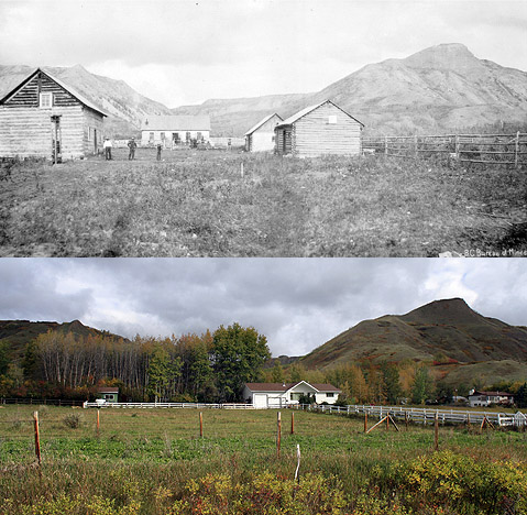
Old Fort St. John Hudson’s Bay Company buildings with map
- Mackenzie, Alexander. The Journals of Alexander Mackenzie: Exploring Across Canada in 1789 and 1793. Santa Barbara, CA: Narrative Press, 20 (Originally published in 1801) ↩
- Mackenzie, The Journals, 220 ↩
- Moss, E. H. 1952. “Grasslands of the Peace River region, Western Canada,” Canadian Journal of Botany 30:98-124 ↩
- Mackenzie, The Journals, 222 ↩
- Mackenzie, The Journals, 229 ↩
- Burley, Prophecy of the Swan: 181 ↩
- George M. Dawson, as quoted in John Macoun. Manitoba and the Great North-West. (Guelph, 1882): 125; also see Stewart, O. C. Forgotten Fires: Native Americans and the Transient Wilderness, edited with introductions by H.T. Lewis and M. K. Anderson. Norman: University of Oklahoma Press, 2002:187 ↩
- Lewis, H. T. “Indian Fires of Spring.” Natural History 89 (1980): 76–83; Lewis, H.T. and T.A. Ferguson. 1988. “Yards, Corridors and Mosaics: How to Burn a Boreal Forest.” Human Ecology 16 (1988): 57-77 ↩
- Ferguson, Theresa. “Aboriginal Prescribed Burning and Landscape History in North Western Alberta” Accessed 02/01/2013 at website:http://www.thefreelibrary.com/Aboriginal+prescribed+burning+and+landscape+history+in+North+Western…-a0233501491 ↩