

Alert Bay, Johnstone’s Strait in 1900 (Harlan Smith, American Museum of Natural History-411790), and in 2014 (CW-2014-05-02-1823). A more closely located, current repeat photograph is required. Alert Bay lies on the island immediately opposite of the site of a large Namgis First Nation village on the mouth of the Nimpkish (Gwa’ni) River visited by Captain George Vancouver in 1792.
July, 1792: George Vancouver on Johnstone’s Strait
After working with the Spaniards mapping the complex shorelines of the Salish Sea in the summer of 1792, Captain Vancouver next proceeded to visit the village of the We Wa Kai people on Cape Mudge, on the southern point of what is now Quadra Island. It overlooks the entry to Discovery Channel on the northwest edge of the Gulf of Georgia. The channel is the southern entry to Johstone’s Strait. This village, like many other communities, was built in a location that secure from unwanted human visitors. On the afternoon of Friday, July 13 he went ashore:
On landing at the village, which is situated a little to the left n.w. within the promontory, and nearly at the summit of a deep sandy cliff, we were received by a man who appeared to be the chief of the party…. he immediately conducted us up to the
village’ by a very narrow path winding diagonally up the cliff, estimated by us to be about an hundred feet in height, and within a few degrees of being perpendicular. Close to the edge of this precipice stood the village, the houses of which were built after the fashion of Nootka, though smaller, not exceeding ten or twelve feet in height, nearly close together in rows, separated by a narrow passage sufficiently wide only for one person. On the beach, at the foot of the cliff, were about seventy canoes of small dimensions, though amongst them were some that would carry at least fifteen persons with great convenience…we were led to consider that this village, though occupying a very small space could not contain less than three hundred persons. The spot where it was erected appeared to be well chosen to insure its protection; the steep lose sandy precipice secured it in front, and its rear was defended by a deep chasm in the rocks ; beyond these was a thick and nearly impenetrable forest: so that the only means of access was by the narrow path we had ascended, which could easily be maintained against very superior numbers. 1
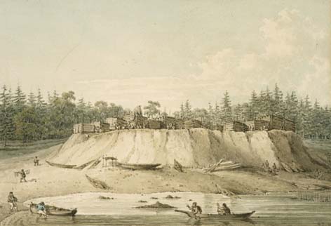
On July 8, Mr. Johnstone, while mapping the strait that now bears his name, passed one of the largest occupied villages yet seen by Vancouver’s expedition. The community of the Namgis people lay at the mouth of the Nimpkish River (Gwa’ni), near the present location of Alert Bay (see above images). Several days later, Vancouver brought the Discovery to anchor in the nearby bay, and visited with the village headman:
Accompanied by some of the officers, Mr. Menzies, and our new guest Cheslakees (Vancouver’s name for the chief), I repaired to the village, and found it pleasantly situated on a sloping hill, above the banks of a fine fresh-water rivulet, discharging itself i
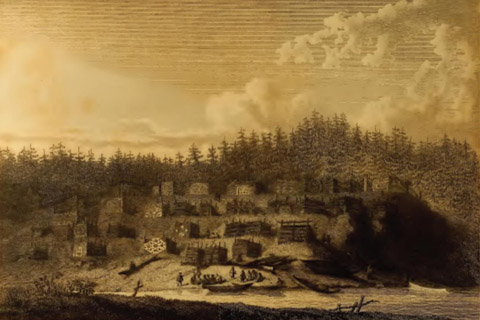
nto a small creek or cove. It was exposed to a southern aspect, whilst higher hills behind, covered with lofty pines, sheltered it completely from the northern winds. The houses, in number thirty-four, were arranged in regular streets; the larger ones were the habitations of the principal people, who had them decorated with paintings and other ornaments, forming various figuresforming various figures, apparently the rude designs of fancy; though it is by no means improbable, they might annex some meaning to the figures they described, too remote, or hieroglyphical, for our comprehension. The house of our leader Cheslakees was distinguished by three rafters of stout timber raised above the roof, according to the architecture of Nootka, though much inferior to those I had there seen, in point of size; the whole, from the opposite side of the creek, presented a very picturesque appearance.…2
Vancouver commented on the affluence of the village. The occupants already possessed several Spanish muskets, possibly traded with people on Nootka Sound that was easily accessible by an overland trail southwards that took only four days. Sea otter skins were common, and several salmon fishing weirs were built across the river.
In August, with the interior channels east of Vancouver Island largely charted, and no great inland waterway yet found, Vancouver’s expedition moved to do an initial survey of the coast to the north. Then, in September, he sailed southwards to Nootka for his meeting with the Spanish, and then on to follow up on the American captain Robert Gray’s possible finding of a large river entering the Pacific Ocean south of the Salish Sea. This proved to be the mouth of Columbia River, a finding of great upcoming significance for both the Americans and the British.
<Previous page Fur Trade Chapter Overview Next page>
Map and Footnotes