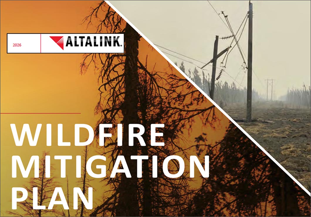
AltaLink’s 2026 assessment of wildfire risk to the Bow Valley’s main transmission line is based upon general forest cover, and only ignitions caused by the line itself. A more robust analysis must include ignitions from all sources, and the probability that they would reach the right-of-way and cause power outages that would impact evacuation and infrastructure protection.
Wildfire Risk in the Bow Valley
In the late 1800s the role of Indigenous peoples using fire to manage the Bow Valley’s vegetation ceased. Historically, these routinely lit Indigenous fires kept forest cover and biomass relatively low, and as a result when fires did occur, these burns were relatively small and had lower intensities. After 1880, with the cessation of frequent burning, biomass began to accumulate.
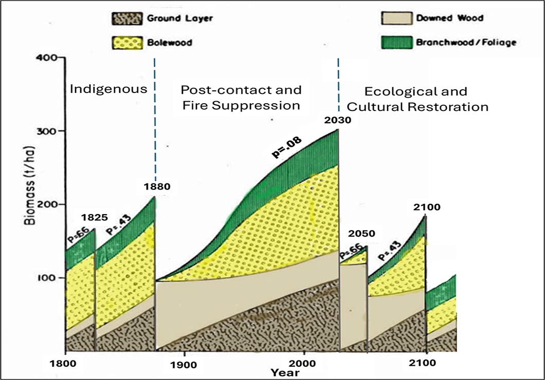
Average biomass accumulation patterns in the montane and warm/dry lower subalpine ecoregions that surround the single AltaLink transmission line that connects Banff and Lake Louise to the Alberta grid in Canmore. The “p” values indicate the probability of a historic interval being at least as long as shown.
Historically, short fire intervals had a high probability of occurrence (e.g., greater than 50% chance would not exceed ~50 years). High fire risk occurs when fire-free periods exceed 100 years and forest biomass exceeds ~150 tons/ha. The above scenario shows that after 1880 fire suppression created an unusually long period fire free period with biomass reaching critical levels (>300 tons/ha) by the 2020s. At this time-since-fire, almost all vegetation type burn will burn hot, killing all trees. The predicted midsummer mega-fire occurs in the year 2030 with unusually high fuel levels (<10% probability) that will burn explosively in a hot, large-area fire—like the recent conflagrations in Waterton (2017) and Jasper (2024). A fire of this intensity and area will likely damage large sections of the transmission line where clearing is less than 25m from dense trees and high surface fuels.
After the extreme fire, the scenario illustrates that intensive forest management is implemented to reduce the pulse of downed wood created by high forest mortality. Then, managers continue to maintain low biomass (<100-150 tons/ha) and mitigate potential wildfire damage to the power line and values at risk in the Bow Valley. This work is prioritized by fine-scale knowledge of sections along the line where probabilities are highest.
AltaLink Risk Assessment for the Bow Valley Transmission Line
AltaLink currently uses a combination of a coarse scale (>10 km) forest cover model, and very fine scale (locations of individual “danger trees) to evaluate the risk that the line itself might ignite a wildfire.
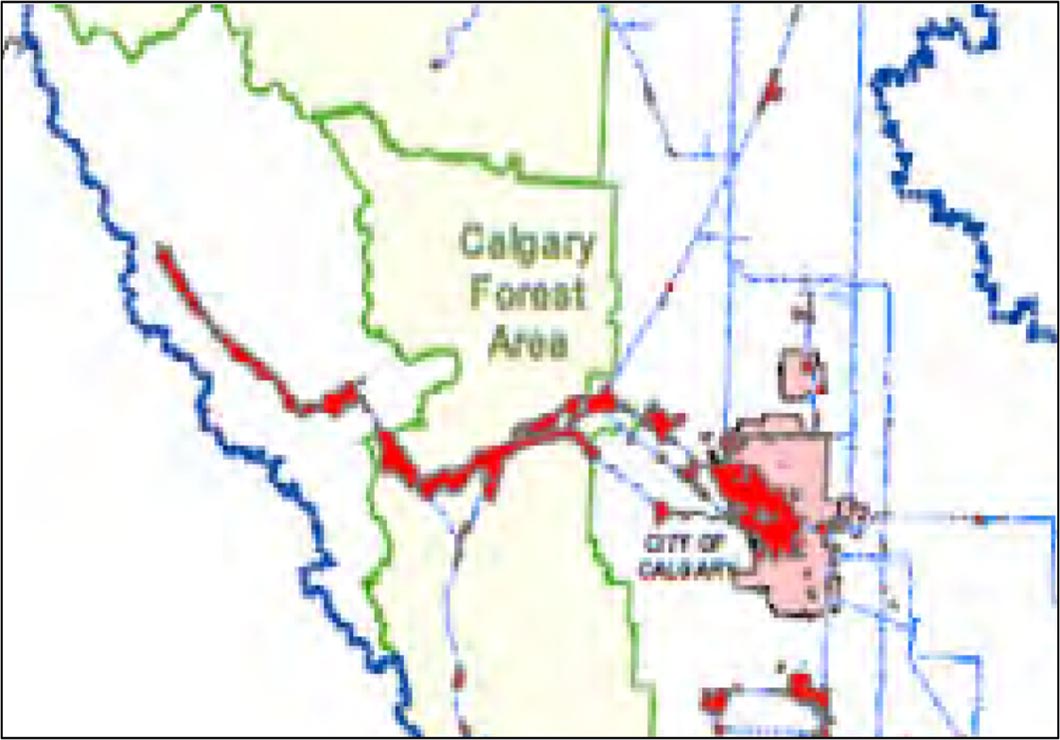
AltaLink (2026) coarse-scale mapping of high fire risk areas (HFRAs) in and near the Bow Valley. The HRFA map for the service territory in and near the Bow Valley is shown above, with the red areas being the HRFAs. Of the provincial total of 13,400 kilometres of transmission lines owned and operated by AltaLink, 2,018 kilometres are located in HRFAs, or approximately 15 per cent of their transmission system.
The HRFAs mapped by AltaLink represent the highest risk locations where the potential impact of wildfires caused by their transmission lines are most significant. The company worked with experts in fire weather science and wildfire risk modelling to simulate the spread and impact of wildfires originating from their assets. HRFA maps are AltaLink’s current understanding of areas of high risk in their service territory.
An Alternate Finer Scale “Total Risk” Approach
Although the HFRA approach described above is commendable from reducing fire risk from the transmission line to adjacent forest, for the Bow Valley it does not address the more significant risk of ignitions from all sources causing fires that spread rapidly and damage the transmission line itself. This is especially critical where the single line west of Canmore to Lake Louise is at high risk from damage from the almost unprecedented amount of biomass in the valley, and the resulting power outages will impact communications, evacuation and the availability of water necessary for suppression.
The state-of-the-art risk approach for the Bow Valley is the “Burn P30+” model– a 30m resolution fire growth simulation that evaluates burn probability from all sources (e.g., highway, railway, power lines, other human sources, lightning), when and where these ignitions are likely to occur, and given fuels and terrain how they will spread. The model culminates fire growth patterns of many fires into maps of burn probability to evaluate various scenarios of input variables.
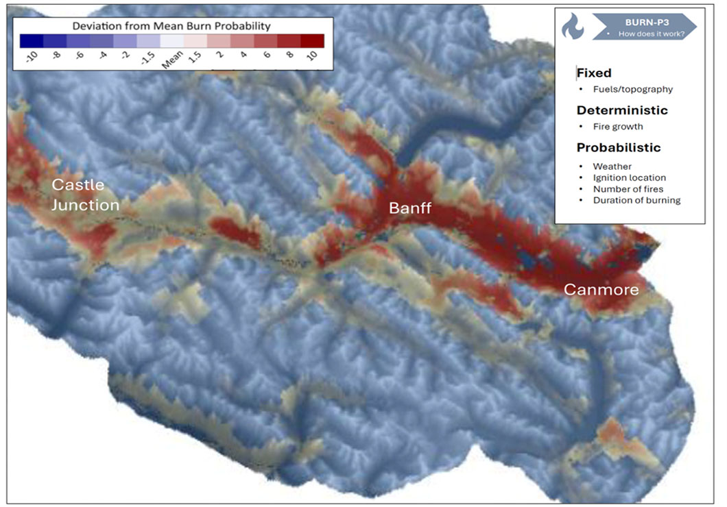
Fine scale burn probability distribution for the Bow Valley and surrounding region as generated by a Burn-P3+ scenario of >1000 fires (from Natural Resources Canada-Apex RMS 2025). The AltaLink transmission line is largely located in the areas of highest burn probability on the south and west facing slopes near the valley bottom.
Once the probability of burning is mapped, potential for damage along sections of the line can be evaluated with model probability distributions for:
- timing (day, time of day, plant phenology)
- rate of fire spread
- direction of fire spread
- fire behavior (flame length, resistance to control, burning residence time)
Additional inputs may be required (time-since-last fire, intensity of last fire), location and density of danger trees, and field checks to validate fuel types and unusual conditions. vegetation impact (tree mortality etc.).
Options for Reducing Wildfire Risk Reduction to Power Line
The fine scale modelling exercise will likely identify extreme areas of wildfire risks along AltaLink’s 51L and 554L single transmission line links Banff and Lake Louise to the Alberta grid in Canmore. With these risks rated and mapped at a finer scale, options to reduce them can be evaluated. Most the line runs though a Designated Wilderness Area (DWA) in the national park. The boundary of the DWA for utility and service corridors including the AltaLink transmission line, is 25 m in perpendicular width from the center of a Right-of-Way (ROW). A wide range of options are available to maintain low vegetation biomass in the ROW. In the adjacent DWA, the federal minister may only permit minimal human activity or infrastructure for essential purposes including: 1) park administration and ecosystem management and 2) Public safety operations and search and rescue. Both these provisions therefore allow vegetation management to reduce wildfire risk in the DWA adjacent to the transmission lines.
Several options to reduce wildfire risk are used along the AltaLink transmission lines:
- Restrict maintenance to low vegetation cover in the 25m ROW and “Danger Trees” only– Maintenance removes individual “danger trees” in the adjacent ROW that might fall on the line and cause ignitions. Wherever possible provide visual screening to reduce aesthetic impacts. This option occurs along the majority distance from Canmore to Lake Louise. It provides optimal vegetation screening for visual aesthetics but does not consider the risk of high intensity fires in the area adjacent to the ROW damaging the line.
- Hand-falling and burning to create “Feathered Glades”– In this option Alta Links legal right of way (25m wide) is machine mulched but select trees or bunches of trees are hand-felled at distances up to ~50m away from the line, limbed/bucked when necessary, and then burned either before or during the prescribed fire. This technique was used along the power line in Sawback and Fairholme prescribed burn units various periods between 1985 to 2003. Routine burning of felled stems over time created a feathered glade that further widens the right-of way. Like other treatments described below, due to lack of ongoing vegetation management, wildfire risks to the powerline are now higher in these sections.
- Machine-felling to widen the right-of-way– The south-eastern half of the 54L section the line in the Fairholm Burn Unit was widened to >40m on either side with trees felled and laid along the edge, and slash piled for subsequent burning either before or during the 2003 Fairholme Prescribed Burn. This treatment is now surrounded by a massive area of dense regenerating pine forest with a massive surface layer of downed wood from the 2003 fire. Due to poor subsequent line clearing and lack of prescribed fire it has extremely high potential for damage from wildfire even with proposed line upgrades. On August 15, 2003 an escape from this treatment into an unburned pile of logs caused a multiple-hour power outage to Banff National Park showing that slash must be treated promptly before a wildfire or prescribed fire occurs.
- Machine-felling to create glades- Where the powerline passed through the Carrot Creek Fuelbreak, feller bunchers removed almost all trees in glades often to distances >100m of the line. Slash was spread and subsequently burned the spring following harvesting, and again in many areas during subsequent maintenance burns. This treatment protected the line during the prescribed fire, and with maintenance burning continued to provide protection for over a decade until maintenance ceased;
- Bury the power line- Given the urgency to reduce mountain pine beetle risk on the broader area, this was not seriously considered in the 1998 to 2000 period of planning. Moreover, it was predicted that once long-term vegetation conditions were restored on the Fairholm Bench, or elsewhere along most of the Canmore to Lake Louise section, the line will lie in meadows, shrublands, young forests, or old-growth Douglas-fir savannas where it would be at less risk and not need to be buried.
- Bundle the powerline- Another option commonly considered is to wherever possible “bundle it” the lined with other infrastructure such as highways, railways or pipelines to create a wide zone of low fire danger that protects infrastructure and often evacuation routes. For the Fairholme Bench area this would be extremely costly and not necessary if long-term vegetation conditions were restored along the existing line’s location. Between Banff and Lake Louise there are several areas where the line closely parallels the railroad and or Bow Valley Parkway, and various tree clearing techniques could be used to bundle the power line with other infrastructure facilitate wild and prescribed fire management, infrastructure protection, and public evacuation if necessary.
Adapting the Existing AltaLink Risk Assessment Paradigm and Risk Mitigation Program
Paradoxically, AltaLink’s current risk assessment focusses on ignitions caused by the company itself, not the greater impact of power outages to people and infrastructure. However, the electrical provider is acutely aware that the greatest risk to power lines in Alberta’s situation is not the ignitions caused by the lines themselves, but from fires spreading into right-of-way from adjacent areas. AltaLink’s 2026 Wildfire Mitigation Plan notes:
During the 2023 wildfires, 48 communities in Alberta were impacted with more than 38,000 Albertans evacuated. While not caused by AltaLink’s electrical infrastructure, these fires resulted in AltaLink’s single greatest loss of assets and required our largest restoration effort to date. (AltaLink 2026)
Thus, for the AltaLink, the communities it serves, and the land managers adjacent to its right-of-way to recognize that they are in an existential mutualistic relationship. The communities and land managers are critically dependent electricity for their survival, especially during a wildfire outbreak. Whether AltaLink can reliably provide this electricity during a period of high wildfire danger is largely dependent on its partnerships with surrounding land management agencies, and political pressure from communities to mitigate problems:
- Are all the partners aware of the escalating fire danger due to biomass increase across the landscape and the specific areas where AltaLink’s transmission line could be at greatest risk?
- Is there a governance model such as “Community Forest” in place that can monitor and rapidly respond to needs to to reduce wildfire risk?
- At a landscape level in the Bow Valley have Parks Canada and Alberta Parks prioritized landscape-scale mitigations that reduce risk the power line (e.g., intensive forest management zoning, fuelbreaks, sequenced prescribed fires etc.?
- Has the past practice of visually screening the transmission line behind mature forest been re-considered given the risk of wildfire damage to the line, the importance of the line to public safety and human infrastructure, and ecological integrity restoration and maintenance objectives?
- In high wildfire probability sections along the powerline are treatments being done to reduce the risk of wildfires damaging the line? These might include: 1) mechanical glading in fuelbreaks, 2) widening of the forest clearing next to the right-of-way, 3) feathered glading, 4) line burial, 5) line bundling with other infrastructure. For most the Bow Valley, a mix of glading and general forest clearing widening (options 1, 2, and 3) are most cost-effective for AltaLink, and compatible with park and protected area vegetation management objectives.
- After treatments have been done are cost-effective maintenance measures being conducted? For glading and clearing options these could include routine use of low-intensity prescribed fire, usually in the early spring or late fall.
- Are operational plans in place on how to use these power line treatments in a wildfire event? ideally this would be burning off the line at night when fire intensity conditions are lowest.
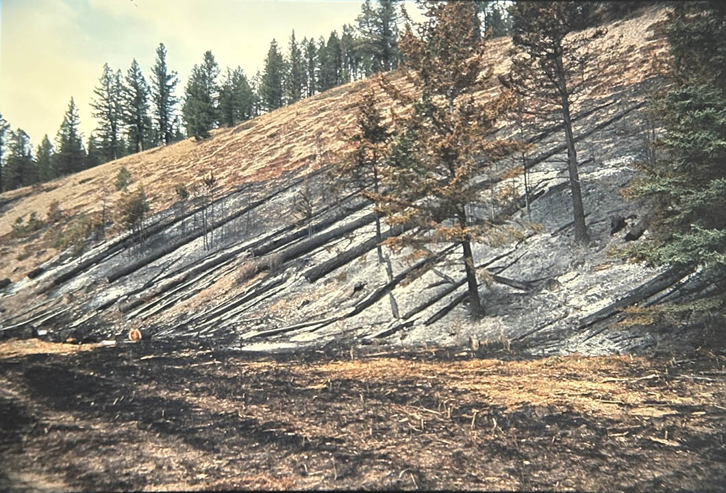
“Feather glading” (midground) and machine mulching (foreground) along the 54L AltaLink line near Johnson’s Lake after low intensity prescribed burning in April 2003. Tall trees adjacent to the right-of-way were felled away from the line, the foliage allowed to dry and then burned in low fire danger conditions. The fire killed younger stands of dense conifers that would eventually create high wildfire risk. Routinely using this method of risk reduction is a low impact method to maintain a relatively natural pattern of open forest and glades near the powerline.
Summary
The Bow Valley is indeed one of Canada’s more unique regions to maintain a critical a single power transmission line that serves a large economic and residential infrastructure. Fortunately, the line follows the historical “least cost” travel route up the lower south and west facing slopes of the valley– historically an Indigenously maintained corridor of frequently burned meadows, shrublands, old-growth Douglas-fir savanna and young pine stands. These vegetation types generally have lower fire intensities that mature older forests. Using high resolution burn probability and wildfire risk analysis, the restoration and maintenance of the long-term “natural” vegetation pattern can be prioritized and will be highly compatible with reducing risk to the AltaLink transmission line.
Return to Pathways Foward Intensive Forest Management Pages
Return to Powerline and Fire Overview page
References
Achuff, P.L., I. Pengelly and J. Wierzchowski. 1996. Vegetation: Cumulative Effects and Ecological Futures Outlook. Chapter 4 in: Green, J., C. Pacas, L. Cornwell and S. Bayley (eds). Ecological Outlooks Project. A Cumulative Effects Assessment and Futures Outlook of the Banff Bow Valley. Prepared for the Banff Bow Valley Study. Department of Canadian Heritage, Ottawa, ON. 47pp.
AltaLink. 2026. Wildfire Mitigation Plan. Calgary, AB. 21p. https://www.altalink.ca/safety-and-preparedness/wildfire-safety/#wildfire-mitigation
Avens Consulting Inc. 2008. Strategic Environmental Assessment of the Fire and Fuel Management Program in the Contiguous Mountain Parks. Final Report. Canmore, AB.
Avens Consulting Inc. 2015. Maintenance Rebuild of the AltaLink 551L Transmission Line Between Banff and Lake Louise: Detailed Environmental Impact Assessment. Canmore, AB.
Avens Consulting Inc. 2025. AltaLink 54L Transmission Line Rebuild in Banff National Park: Detailed Environmental Assessment. Canmore, AB. https://www.altalink.ca/project/54l/
Natural Resources Canada and Apex RMS. 2025. Burn P3+: A new multi-model fire simulator based upon Burn-P3+. Powerpoint Presentation. Natural Resources Canada. Edmonton, AB.
Stockdale, Chris, Brett Moore, Elysse Mathieu, et al. 2022. Wildfire Risk to Parks Canada Town Sites in Banff, Yoho, Kootenay, Jasper, Waterton Lakes and Riding Mountain National Parks. Project. Natural Resources Canada.
Tymstra C, RW Bryce, BM Wotton, OB Armitage. Development and structure of the Prometheus: the Canadian wildland fire growth simulation model. Inf. Rep. NOR-X-417, Nat. Resour. Can., Can. For. Serv., North. For. Cent., Edmonton, AB (2010) 102 pp.
White, Clifford A. 1985. “Fire and Biomass in Banff National Park Closed Forests.” Colorado State University.