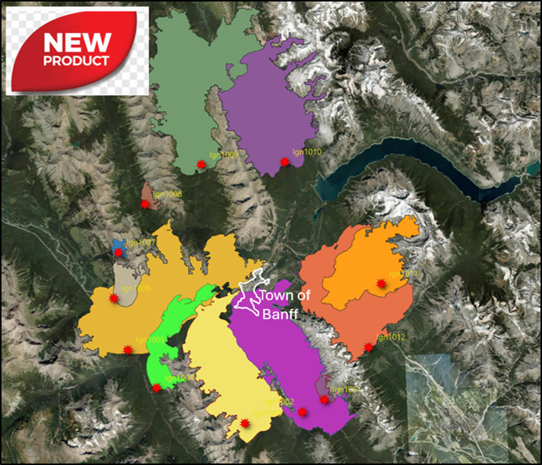
Wildland fire researchers have simulated growth patterns for fires positioned around the Town of Banff under recent patterns of fuel accumulation and extreme fire weather.
UNDERSTANDING WILDFIRE THREAT AROUND THE TOWN OF BANFF AND IMPLICATIONS FOR EVACUTATION TIMES
By M-P. Rogeau, C. White, M. Heathcott, K. Hirsch and R. Arthur
July, 2026
Background
The Town of Banff is located amidst complex terrain where various valleys join in with the Bow Valley, and where steep slopes border several portions of the Town’s perimeter. The vast majority of the surrounding landscape is covered with mature forests that have not burned in over a century. Tree-ring science and charcoal studies from lake-bottom sediments have informed us that forest and grassland fires were common occurrence in the Bow Valley through the centuries, up until the onset of effective fire suppression starting in the mid-1900s. As forests mature beyond their life expectancy and start dying off, they become more vulnerable to wind events, and insect epidemics or diseases. When ignited, older forests contain a lot more biomass (fuel) to stoke a fire making fire suppression far more difficult.
Rugged terrain influences fire behaviour in various ways which brings additional challenging conditions for firefighting. Steep slopes mean a faster rate of spread uphill, warm-facing aspects harness the sun’s energy and contain much drier fuels facilitating fire spread and most importantly, winds get funneled and bent through valleys creating uneven wind speeds and erratic wind directions.
To help with the understanding of wildfire spread patterns around town, as well as situations that could challenge a complete evacuation, computer wildfire simulations using Prometheus were employed. Prometheus is a computer-based fire growth program derived from the Canadian Fire Behaviour Prediction (FBP) model and used by many lead fire agencies. It was developed in Canada for our boreal vegetation types and wildfires (Hirsch 1996, Wotton et al. 2009). Fire growth models are a tool to better understand potential fire behaviour and help with the decision-making process of fuel management and real-time operational use during a wildfire. Wildfire scenario predictions around the Town of Banff are expected to be relatively accurate due to the high resolution of the vegetation cover map, the Digital Elevation Model, and data from a weather station located at the heart of the simulations.
Two notes of caution. 1) Prometheus does not account for spotting, which can vastly modify or accelerate fire spread and the time of arrival to assets at risk. 2) Prometheus uses an embedded wind prediction model that determines wind flow direction (i.e. fire spread direction). It was found during the simulations that some spread patterns are not entirely accurate when compared to on the ground observations.
Wildfire scenarios
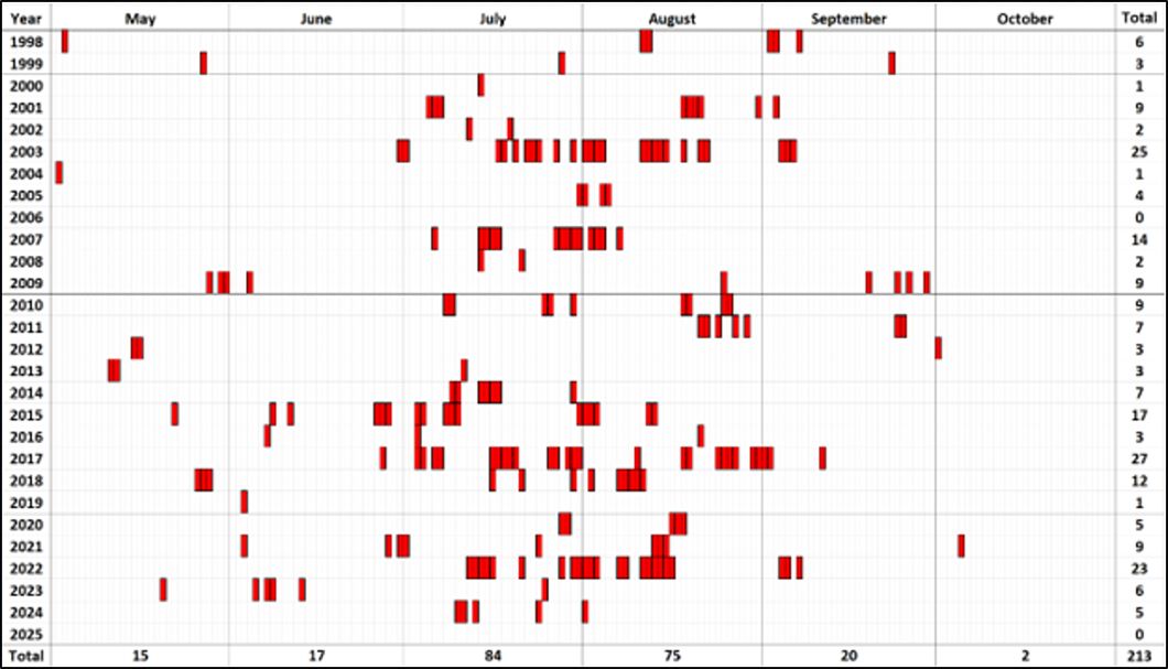
This study concerned itself only with Rank 6 fires when Head Fire Intensity (HFI) exceeds 10 000 kW/hr. These fires represent blow-up fire weather situations when a forest can be engulfed withing minutes and when fire suppression capacities become inadequate even shortly after ignition (e.g. Jasper fire). A review of daily fire weather indices calculated from the Banff weather station located near the warden office for the period of 1998 to 2025 identified 214 days fitting this profile (Table 1). If this exercise would have been repeated using hourly weather observations, many more days would have been highlighted as having the potential for blow-up conditions during a few hours in the afternoon, typically between 14:00 and 18:00.
Table 1: Red boxes represent blow-up days where there was the potential for out-of-control fires to ignite between 1998 and 2025 (from Heathcott 2025).
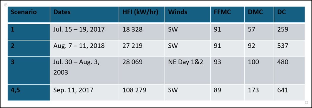
Three scenarios capturing blow-up potential lasting 5 days in a row and depicting the low and high range of HFI were chosen (Table 2). Scenarios 1 and 2 are representative of prevailing wind conditions observed around Banff when fire danger is high that >80% of the time winds blow from the S-SW-W, and when the danger is extreme the wind is from these directions in nearly all days (Hirsch and Heathcott 2025). When a low-pressure system moves across the area, this changes to a brief period of northeasterly winds and this is captured in Scenario 3. These northeast winds are light, and soon followed by rain if a SW flow does not re-occur. Scenarios 4 and 5 capture a 1-day fire spread event representing the worst day ever recorded: Sept. 11 2017 – day of the Waterton Kenow Fire and when the Verdant Creek fire was burning near Sunshine Village. The worst-case scenario was used twice under mean wind speeds of 30km/hr (Scenario 4) and then modified to increase the wind to 50 km/hr for a single hour (Scenario 5) in an attempt to capture gusty conditions that lasted several hours on that day.
Table 2: Scenarios chosen for fire growth simulations.
To remove bias, ignitions were positioned along a 5-km and 10-km distance radii from the ToB (Figure 1). Along each radius, 12 ignitions were positioned so that approximately three ignitions fell in each quadrant. Ignitions were positioned to ensure that each valley had an ignition. Ignitions were placed mid- to upper-slope to mimic lightning ignitions. If a trail was nearby, the ignition was moved closer to the trail as a potential human ignition. Ignitions were set to start at 15:00 (3 pm) and were run until 23:00 of Day 4. For the one-day event of Scenarios 4 and 5, ignition start time was set to 11:00 and the simulation ended at 23:00.
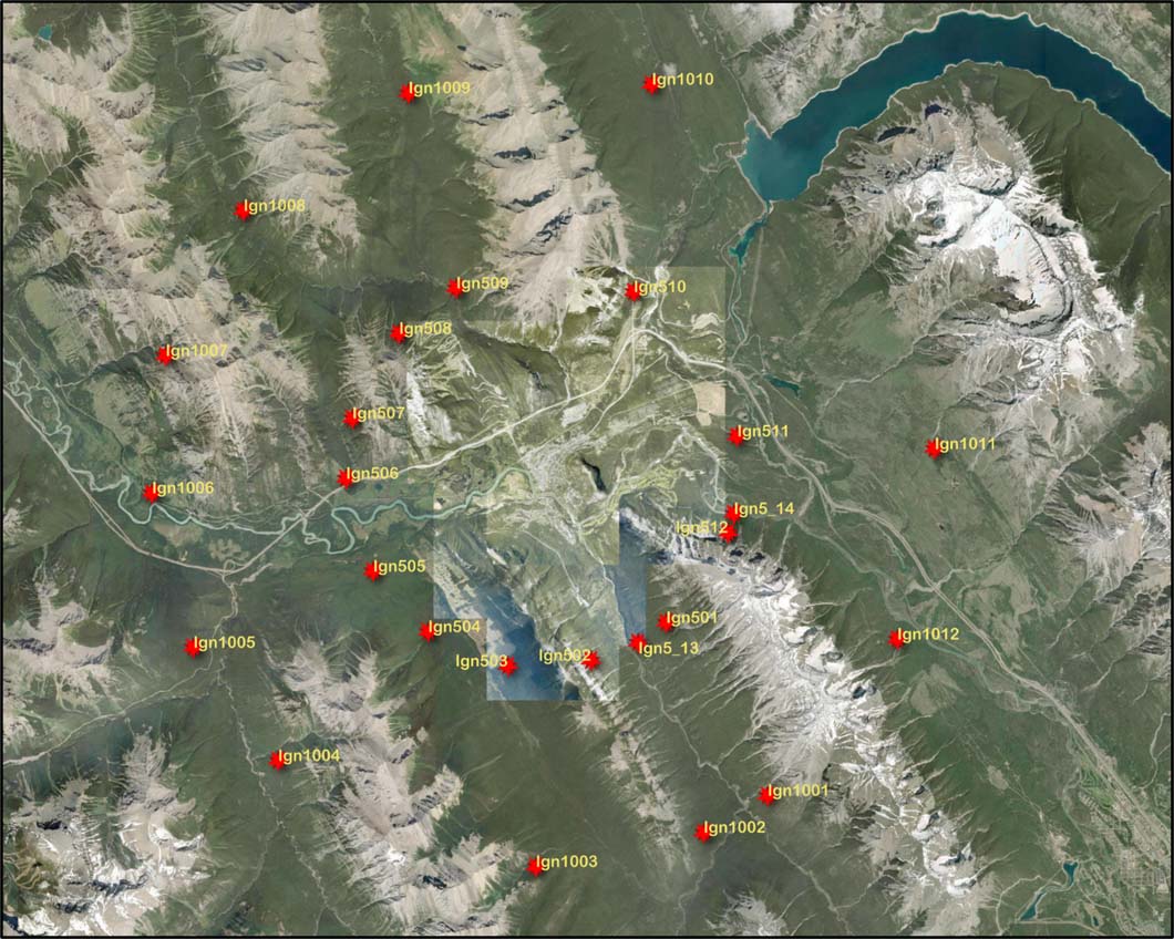
Figure 1: Pattern for postioning ignitions at 5-km and 10-km radii from Town of Banff for fire growth simulations.
Other inputs required for the Prometheus model were:
- Fuels- A 100m resolution FBP map within 30-km radius of Banff was corrected for non-fuel polygons, current vegetation in old fire guards and prescribed burns, assigning a slash fuel type to recent fire guards, assigning infrastructure to a C3 or C7 type, assigning rivers as C3 (dominant surrounding vegetation), and roads as a grass type. C3 was modified to a 4m crown base due to aging forest and growth of understory spruce trees.
- Terrain– A 100m Digital Terrain Model was created from the original 30m resolution model.
- Wind– Speed and direction grids created by “Wind Ninja” at 100m resolution were used in simulations.
Results of Simulations
Figure 2 shows results of 10 km ignition-point simulations. Ignitions to the west and southwest of town, driven by the winds most common on high fire danger days are the most problematic. Ignitions 10 km to the north and east of town spread into more remote areas of the park.
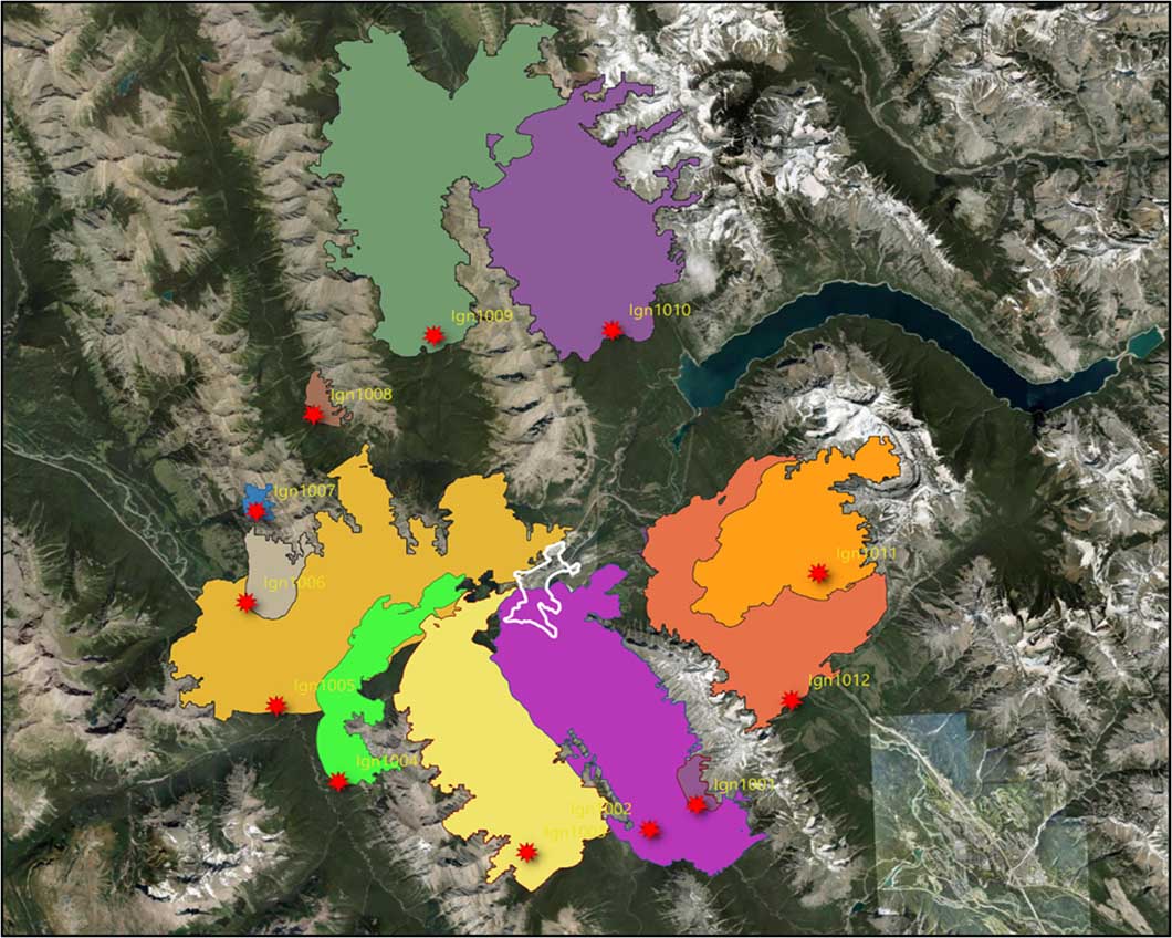
Figure 2. One-day wildfire event (Scenario 4 – prevailing winds from the SW) for ignitions starting 10 km away from the Town of Banff (white outline). Ignition locations 2, 3, 4 and 5 are most problematic.
The hourly growth predicted for ignition 10-02 on the south end of Sulphur Mountain (Figure 3) specifically shows how southwest winds may drive a fire across the lower Spray Valley, onto the slopes of Mount Rundle, then rapidly advance towards the town in a valley-wide conflagration.
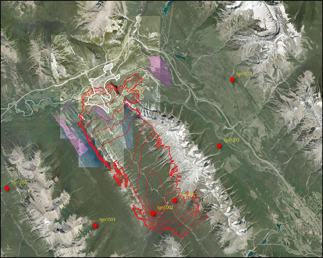
Figure 3. Hourly perimeter growth (red lines) from ignition 10-02, at 10-km distance. Within 7-8 hours, the south portion of town is compromised.
The importance of the position of ignitions on valley slope are shown by the hourly spread simulations from the 5-km distant ignitions (Figure 4). Ignitions 1 and 2 located along upper-slopes are quickly fanned by high winds into the rocky alpine zone. While an ignition on the SW-facing slope (ignition 5-01) buys time and reduces the immediate risk to the ToB, ignition 5-02 indicates that Sulphur Mountain gondola assets could quickly get compromised with little time for safe evacuation due to the forested ridge. An ignition positioned on the lower slopes or at valley bottom (ignition 5-13) has a vastly different consequence with a rapid spread towards town where assets would be engulfed within 7 to 8 hours. Enough mature timber exists to create a 300 ft wall of flame as it reaches town.
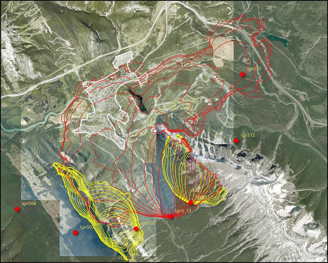
Figure 4: The relevance of ignition position along a valley slope coincident with wind conditions shows a highly variable outcome under high-velocity winds from the SW (Scenario 4 – 5 km distance ignitions).
In contrast, the 10-km distance ignition 10-02 for the same scenario (Scenario 4) has Town assets engulfed within 8 to 11 hours (Figure 2). A more distant scenario has a greater consequence on the ability to fight such fire as it will have had the chance to develop a high-intensity fire front spreading from treeline-to-treeline with accelerated momentum. Scenario 5, which considers a single hour of 50 km/hr winds to make up for gusty conditions not considered in hourly wind records, pushes the time of fire arrival to 5 to 8 hours–far too short for a full evacuation.
Time of Fire Arrival in Town and Evacuation Implications
For ignitions starting 10 km away from Town, results show that the 1-day worst-case scenario challenges evacuation time (less than 12 hours) for all ignitions upwind from town and starting in the Spray, Brewster, Sundance or Bow Valleys (Table 3). Other scenarios under less critical head fire intensity with upwind ignitions would reach town between 24 to 27 hours prompting an evacuation with a high-likelihood of success.
Table 3: Time of arrival fires reaching Town of Banff for 10 km distant scenarios.
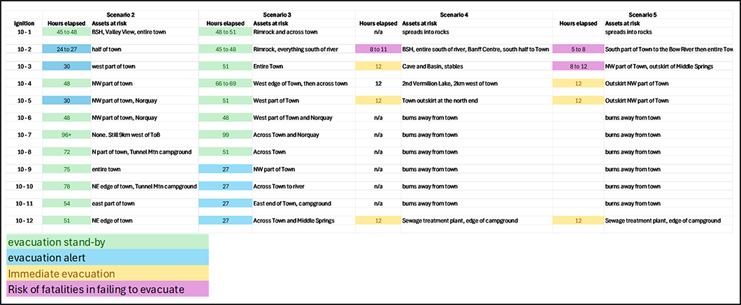
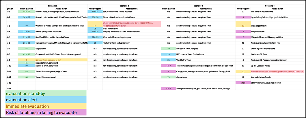
For the 5-km ignitions (Table 4), the worst-case scenario simulations produced a number of situations where immediate evacuations are triggered with a failure to fully evacuate including the potential risk of fatalities. As for the remaining less extreme blow-up scenarios, similarly to the 10-km distance ignitions, time to assets ranges between 21 to 30 hours which provides greater chances of full evacuation success. It is important to understand that these are conservative values as Prometheus cannot model fire spotting ahead of the fire front, and hourly mean wind speeds downplay the rate of fire spread under gusty conditions.
Table 4: Time of arrival fires reaching Town of Banff for 10 km distant scenarios.
Conclusion and Recommendations
The results of this study indicate that under certain, but historically accurate conditions, the town of Banff may be hard pressed to fully evacuate the town and is still currently subject to near catastrophic urban conflagration. While there have been noticeable improvements on the fuel mitigation front on the part of the ToB, Parks Canada, and many property owners, our collective wildfire resilience is still low with far too many problematic properties that are easy to ignite during ember showers and posing a significant risk of urban conflagration with neighbouring properties positioned downwind.
Fine-scale wind models– Regional winds during high fire danger are predominantly from the west and southwest. However, at finer scales the wind modelling component (a sub-model of Prometheus and also used in Burn-P3) has limitations in complex topography and can produce erroneous fire spread patterns in some circumstances. Through local observations it was also found that winds can be counter-intuitive and misaligned with what is recorded at the Banff weather station. It is crucial for fire preparedness to better understand how the wind blows around town and within the general vicinity in the Bow Valley.
Interaction of wind and structures- We recommend a study of wind-driven pathways through the town that intersect with poor FireSmart scoring properties be undertaken without delay. For the sake of transparency, scoring results should be made public and used as a supplemental tool for public education. Some may not worry about losing their own assets to a fire, but their attitude translates into a substantial risk of neighbourhood conflagration and losing numerous properties if not several blocks. If you have several properties with poor scores igniting at once from falling embers, it becomes a recipe for losing most of the town.
Evacuation (or not)- We also recommend for Emergency Services to identify locations that can serve as a safe shelter-in-place (outdoors and indoors) as soon as possible. Exterior locations need to address the number of people it could possibly shelter, keep on-site containers filled with robust fire blankets, masks, goggles and burn kits. There will be a need to mitigate for wildlife precautions as these safe sites will also be used or traversed by wildlife of all sorts fleeing the fire. The next Evacuation Guide needs to include shelter-in-place locations and assign them to town evacuation zones, as well as the sequential order of evacuation zones based on the location of the fire and prevailing winds.
Town periphery forest management– For avoiding direct ignitions from the burning forest to properties, fuel reduction must occur at least 30 to 50m around the town’s perimeter with a priority in the west to south quadrant of town.
Landscape-level fuel reduction prioritized for upwind areas- These include the Spray (most urgent), Sundance, Brewster and the Bow Valley watersheds south and west of Town. A combination of harvesting and prescribed burning are recommended, along with a maintenance program.
Return to Burning Banff Overview page
References
Heathcott, M. 2025. Banff Daily Fire Weather Index. Banff FRG (Fire Research Group). https://lensoftimenorthwest.com/themes/burning-banff/fire-risk-box/fire-weather/banff-daily-fire-weather-index/
Hirsch, K. G. 1996. Canadian Forest Fire Behavior Prediction (FBP) System: user’s guide. Special Report 7. Canadian Forest Service, Northern Forestry Centre. Edmonton, AB. 122p.
Hirsch, K. G. and M. Heathcott 2025. Banff Wind Speed and Direction: 1961-2025. Banff FRG (Fire Research Group). https://lensoftimenorthwest.com/wp-content/uploads/2025/12/Hirsch-and-Heathcott-2025-Banff-Wind-Rose-Fire-Weather-Analysis-1961-2025.pdf
Tymstra, C., R.W. Bryce, B.M. Wotton, S.W. Taylor and O.B. Armitage. 2010. Development and Structure of Prometheus: The Canadian Wildland Fire Growth Simulation Model. Information Report NOR-X-417. Canadian Forest Service, Northern Forestry Centre. Edmonton, AB. 88p.
Wotton, B.M., M.E. Alexander and S.W. Taylor. 2009. Updates and revisions to the 1992 Canadian Forest Fire Behavior Prediction System. Information Report GLC-X-10. Great Lakes Forestry Centre. Sault Sainte Marie, ON. 45p.
Authors biographies
- Marie-Pierre Rogeau, PhD. 35 years of experience. Studied and consulted in the field of wildfire science starting in 1991. Her main focus has been on the effect of topography on fire frequency in the mountains, fire history studies, fire regime simulations, fuel load assessments and wildfire threat assessments to values at risk.
- Cliff White, PhD. 47 years of experience. Was Banff National Park’s vegetation and fire specialist from 1979 to 1986 then served as Parks Canada’s first National Fire Management Officer in Ottawa. Later he returned to Banff and managed Banff’s ecological research and restoration program for two decades. The program integrated prescribed fires with wildlife and vegetation objectives to protect public safety and infrastructure while maintaining park ecological integrity. CW and Associates only take on enough paid work to keep the accountant happy, and otherwise practice more esoteric ecology.
- Mark Heathcott, B.Sc. 45 years of experience. Started his career for the Alberta Government in 1981 on the Initial Attack Crew for two years, followed by a 22-year career with Parks Canada in various roles including being the National and Regional Fire Management Officer coordinating fire management and controlled burns in Western Canada until his retirement in 2007. Since, he has been freelancing with a focus on analyzing fire weather data, wildfire case studies and fire history.
- Kelvin Hirsch, M.Sc. 41 years of experience. Started his career with the Canadian Forest Service as a technology transfer specialist in the field of forest fires in 1985 out of Winnipeg. His career evolved to a forest fire research officer, research manager in the science-policy division to finish his career as director of the Climate Change and Forest Research group at the Northern Forestry Centre in Edmonton. Since his retirement in 2017, he has been consulting and has taken an interest in volunteering his time as an advisor.
- Rick Arthur, Forest Technologist diploma. 50 years of continuous experience with feet in ashes from both wild and prescribed fires. He spent his 38+ year career with the Alberta Government starting as a seasonal fire crew in 1974 to various fire operation positions, ending his career in Calgary as the Wildfire Prevention Officer. One of the instigators of the Partners in Protection program for Fire Smarting landscapes and properties. Passionate about fire history, fire behaviour and fire ecology. Post-retirement has been spent consulting and working for FRIAA to provide advice to communities working to reduce their wildfire risk.