


This gallery of internet images show how, driven by a southwest air flow, the “Jasper South Fire” advanced northwards down the Athabasca Valley from July 22-26, 2024 into the townsite. Forest biomass conditions in the valley were likely unprecedented with <5% probability of this occurring for a small area, and much less for the whole valley.
Historically, fires in the middle Athabasca valley were relatively common with a frequency of <40 years on the valley bottom ranging up >80 years on upper slopes (Tande 1979, Chavardès et al. 2018). Indigenous peoples probably lit most of these burns in moderate fire weather conditions—constraining the area burned and the intensity/severity of the fires. Assuming an average fire cycle of 60 years, and characterizing biomass by vegetation types classified by the Banff-Jasper Ecological Land Classification (Achuff and Corns 1982) yields estimates of representative biomass conditions over time for the montane and warm/dry lower subalpine ecoregions (White 1985).
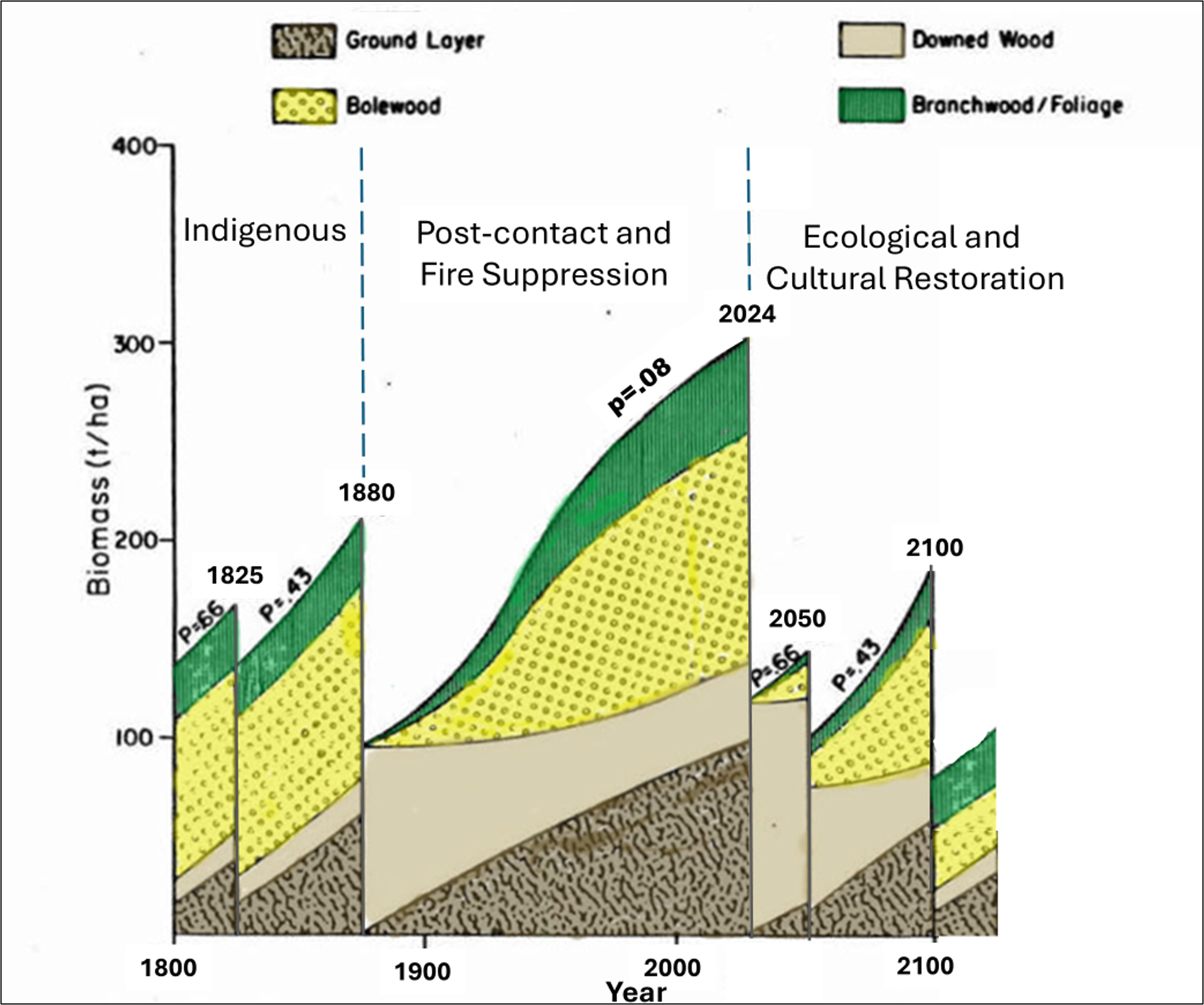
A biomass scenario for the Athabasca Valley south of Jasper townsite with a ~60 year fire cycle prior 1880, post-contact and fire suppression from 1880 to 2024, followed by potential restoration of a long-term fire cycle near the town. This restoration would gradually reduce the massive pulse of dead and downed wood created by the intense 2024 fire (~100 tons/ha) and favour a more mega-fire resistant landscape of grasslands, riparian shrublands, aspen, young lodgepole and mature Douglas-fir with low downed wood and forest floor biomass. The “p” values indicate the probability the fire interval would be at least as long as shown.
Assuming relatively constant climate and an equal flammability with stand age, the scenario shows the probability that the fire intervals would be at least as long as shown. During the Indigenous period, the 1825 and 1880 pre-fire intervals had high probabilities of occurring. Moderate fire intensities would have only partially burned the forests, with biomass averaging between 100-200 tons/ha. However, during the post-contact and fire suppression periods (~1880 to 2024) a long fire-free period occurred that would have had only very low probably of occurring in previous times (p=.08). As a result, relatively high levels of total biomass (~300 tons/ha) occurred across the landscape. Through decomposition, downed wood biomass declined during the early 1900s before beginning to increase in the 1990s as lodgepole died from mountain pine beetle attacks. Ground fuels, and canopy bolewood, branchwood and foliage biomass increased steadily during the period. Combined with a decreasing height to live crown foliage, and denser forest foliage this created high crown fire potential. Increased common juniper cover (an explosive shrub component) also likely created conditions for intense surface fires that rapidly transition into full crown fire. This pattern of biomass accumulation change made the fuel complexes favouring the extreme fire behavior of the 2024 burn (JFT 2025).
Next what was required was a period drought and hot weather to dry out these fuels. During the 23-day span July 1-22, 2024 the fire weather Buildup Index increased rapidly from a near-median value to an extreme level (BUI of 169), the highest value recorded for that time of year and above the 99th percentile of observations for a 62-year climatological record (JFT 2025). Under these conditions extreme fire behaviour would be expected during “30-30-30” conditions (>30 degrees C,<30% RH, >30 km per hour winds). Now, all was required was a source of ignition. On July 22 the ridge of high pressure that created the drought shifted eastwards. During the day strong SW winds blew a wave of super-heated and dried air from the deserts of Washington and Oregon northwards across the Canadian border, up the Rocky Mountain Trench and finally, by mid-afternoon over the mountain passes into the eastern slope watersheds. Here the hot air blast encountered a cooler air mass, creating sporadic lightning, with several strikes in the Athabasca Valley. Ignitions occurred in at least 2 locations, and within minutes the nearly unstoppable Jasper South megafire erupted– advancing through a continuous blanket of extremely abundant fuels towards the town (JFT 2025). Within 4 days over 360 square kilometers were baked and blackened, with a massive release of carbon from the ground, downed wood and crown foliage layers– reducing total biomass from ~300 tons to <100 tons per hectare. Amazingly, the town itself and surrounding resorts were only about 1/3 burned partially due to years of FireSmart fuel reduction near buildings and fuelbreak cutting on the town’s periphery (Westhaver et al. 2007). Most important however was the arrival of the cold front that had been pushing the southwest winds. This brought an easterly windshift, cooler temperatures and rain showers. Although rather extreme, the weather pattern itself followed a relatively typical pattern for eastern slope Canadian Rockies fires (Baker 1985).
After the burn, the major source of remaining biomass is the dead standing trees that fall over time to the forest floor. The fuel accumulation scenario illustrated above is based on a prediction that managers will practice active ecological and cultural restoration in the Athabasca valley over the next few decades. Prescribed burning–likely partially based on the long-term Indigenous practices of “burn early, burn often, burn light” will return fire frequency to more characteristic intervals of <60 years. An initial task will be to construct fuelbreaks and reduce the massive pulse of downed wood biomass created by the 2024 burn. Over time more frequent burning within the breaks will maintain generally lower biomass levels, and return to a healthier and younger vegetation adapted to ongoing moderate fire intensities.
Is the Banff-Canmore Bow Valley following the Jasper 2024 scenario? YES —biomass is accumulating in a similar pattern after the Indigenous depopulation of the 1800s (Binnema and Niemi 2006). Two interacting factors have slightly reduced risk: 1) slightly younger forests due to a 30-year period of railroad-caused fires the maintained the fire regime along the Indigenous travel route through the valley, and 2) perhaps due to the overall younger trees and higher elevations, mountain pine beetle is only now beginning to rapidly kill the aged lodgepole forests. Perhaps land managers can use this fortunate “window-in-time” to reduce fuel abundance and continuity before the inevitable big burn.
Return to Wildfire Risk Reduction section.
References
Achuff, P. L., and I. G. W. Corns. 1982. “Vegetation.” In Ecological (Biophysical) Land Classification of Banff and Jasper National Parks. Volume 2: Soil and Vegetation Resources, edited by W.D. Holland and G.M. Coen,. Edmonton: Alberta Institute of PedologyVolume 2: Soil and Vegetation Resources, edited by W.D. Holland and G.M. Coen,. Edmonton: Alberta Institute of Pedology.
Baker, K. A. 1984. Weather patterns and wildland fire in Banff National Park. Technical Report. Warden Service. Parks Canada. Banff, AB.
Chavardès, Raphaël D., Lori D. Daniels, Ze’ev Gedalof, and David W. Andison. 2018. “Human Influences Superseded Climate to Disrupt the 20th Century Fire Regime in Jasper National Park, Canada.” Dendrochronologia 48 (April): 10–19. https://doi.org/10.1016/j.dendro.2018.01.002.
JFT (Jasper Fire Documentation, Reconstruction, and Analysis Task Team). 2025. Jasper Wildfire Complex: Fire Behaviour Documentation, Reconstruction, and Analysis. Information Report NOR-X-433. Northern Forest Research Centre.
Tande, Gerald F. 1979. “Fire history and vegetation pattern of coniferous forests in Jasper National Park, Alberta.” Canadian Journal of Botany 57 (18): 1912–31. https://doi.org/10.1139/b79-241.
Van Wagner, C. E., M. A. Finney, and M. J. Heathcott. 2006. “Historical Fire Cycles in the Canadian Rocky Mountains.” Forest Science 52: 707–17.
White, Clifford A. 1985. “Fire and Biomass in Banff National Park Closed Forests.” Colorado State University.
Westhaver, Alan, Brad C. Hawkes, and Richard D. Revel. 2007. “FireSmart & ForestWise: Managing Wildlife and Wildfire Risk in the Wildland/Urban Interface-a Canadian Case Study.” The Fire Environment–Innovations, Management, and Policy; Conference Proceedings. (Fort Collins, CO) Proceedings RMRS-P-46: 347–65.