
Explosive behaviour of the September 1994 Red Deer Prescribed Burn as it advances into pine forests on the edge of Tyrell Creek meadows.
For Rocky Mountain fire behaviour aficionados, a classic ring-side seat is to watch the rapid transition in flame length and rates of spread as a grass fire at the edge of a meadow runs into the adjacent forest. On the downwind and warm SW facing fringes of these meadows flame lengths of less than 2m rapidly jump to over 50m. Here fires first begin to “candle” as they torch the open-grown conifers with low heights to live crown. This then often triggers a full-scale crown fire that can sometimes run for kilometers on dryer sites. Interestingly there is a common belief that Indigenous peoples could, through powers-unknown, carefully contain fires in these meadows. As native fire practitioners are again allowed to restore and maintain ecological integrity in parks and protected areas romantic perceptions versus reality can be explored.
Case History: The Compound Meadow Burn
Probably the first awareness that Banffites had of a new prescribed burning direction in the Bow Valley is when Parks Canada approved two small prescribed burns near Banff Townsite shown in the 2020 Plan. Crews lit the “Airport Meadows” in the spring of 2022, and the following spring ignited the “Compound Meadows” on the other side of the highway.


Various views of the iconic “Welcome to Banff” sign from 1950s until the Compound Meadows prescribed fire encountered its 2023 version, and continued eastwards following historic burning patterns. Fortunately, “meadow burning” was not put back on the ecological maintenance schedule until after Marilyn Munroe posed with the sign in 1953.
This burn made national news when on May 3rd, 2023 it went out of control, burnt up the “Welcome to Banff” sign (of Marilyn Munroe and Bill Peyto fame), then crossed Banff Avenue and ran a couple hundred meters to the edge of the cemetery and into the community horse corrals. On a prescribed fire in a more remote area this would be considered normal fire behavior as the short flames in the grass meet the adjacent forest. However here– immediately next to the Town of Banff– this was national news. The damage to the local citizen’s property and destruction of the landmark sign made it even worse.
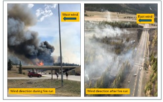
Compound Meadows Burn Fire Escape: Unstable weather during guard burning resulted in sharply increasing west winds followed by a switch to a easterly direction. High perimeter to area ratios leave little room for error on small “meadow burns” and frequently the forest around meadows is also very dry and will easily carry a much higher intensity fire than the central grassland.
The Math of Meadow Fires
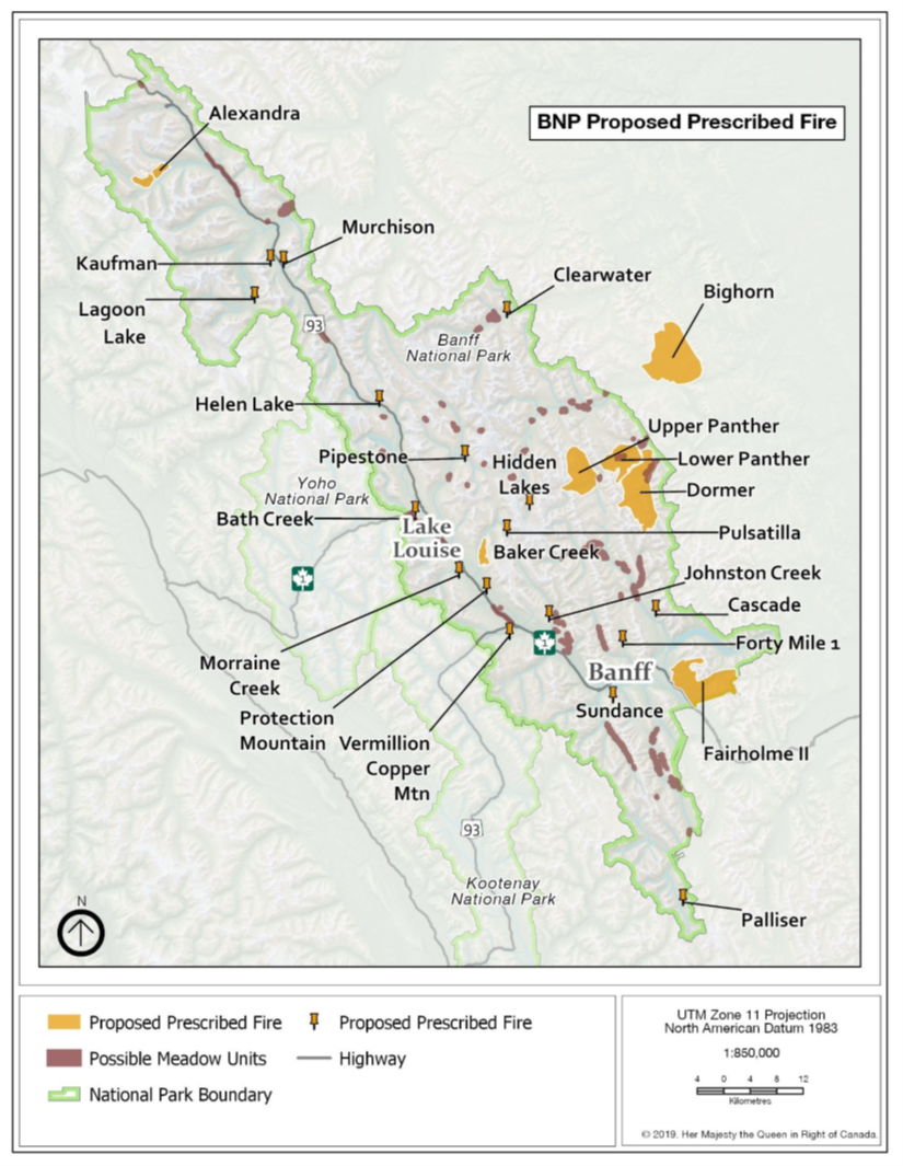
Clearly some of the error on the Compound Meadows burn lies with the Parks Canada team choosing to burn with a forecast of a moderate probability of unstable weather that afternoon, but a deeper systematic flaw lies within the strategies of the recently approved 2020 Fire Management Plan. The new plan emphasized small (1-2 km2) “meadow burns” in the on the valley-floor of the Bow and other valleys, while restricting the number of larger 10-20 km2 burns that had been the norm in the period 1990 to 2015. This may have seemed to be safer to park managers but consider that Banff needs to burn at least 8-10 km2 per year in the Bow Valley. So consider this simple relationship:
- An area of 9 square km could be done with 1 large, prescribed fire per year with about 3 km per side, or a perimeter of about 12 km. Given the larger size of the burn, much of this perimeter could likely be abutted against rock ridges, rivers, previous burns, or other good fuel breaks. This reduces the needs for large crews or water hoses, pumps etc. Further this single burn could likely be done in 1-2 days of optimal weather.
- At the other extreme, as required by the 2020 Fire Plan the 9 km2 should be achieved with 9 “meadow burns” of say about 1 sq km, each with a perimeter of approximately 4 km, or a total perimeter of 36 km. The meadow burns themselves would be difficult to control due to large perimeter to area ratios, edges of flammable conifers, fewer opportunities to use large terrain features fuel breaks, and 9 burns would take 9-18 days with greater risk of having dangerous weather on some burns.
From this perspective the change in fire management direction clearly increased risk. The 2020 Fire Plan prescribes many dozens of these units for Banff, Yoho and Kootenay national parks.
Perhaps Parks Canada is fortunate that it only took a few burns, the incineration of the classic “Welcome to Banff” sign, some small buildings, and a couple fence lines and of course a tough blow to the egos of an experienced burning team to discover this failed logic in understanding fire behavior.
The Myth of Meadow Burns?
Historically there were few pure “meadows”—the past landscape was a mosaic of grasslands, shrublands and young conifers, and average fire sizes and area burned was much greater than could have ever been achieved with the 2020 Fire Plan. Moreover, these historic mosaic of vegetation often abut steep south facing slopes that are very dry and will clearly carry fire’s further than the adjacent grassland. In a focussed study on Banff and Jasper meadows fire history park biologists collected fire-scarred tree wedges from the perimeter and at 200 meters further distant for 9 meadows on the eastern slopes from northern Jasper south to the Kananaskis valley. The scars usually occurred in the dormant or earlywood sections of the rings, suggesting that past fires were likely Indigenously lit from late fall into the spring season. But the historic burns were not constrained to meadow edges—although they may have been started on the upwind edges, the past fires often clearly spread far beyond the current meadow perimeter . So “over-achievements” like the Compound Meadows burn were also common historically—this would not be a surprise to those Indigenous folks that lit them.
Of course, in past times these larger fires posed little risk to a thoughtfully placed Indigenous camp and were simply part of the ecological and cultural mosaic. In fact, as shown in the historic image below, the traditional Stoney Nakoda campsite location in the meadows may reflect these considerations.
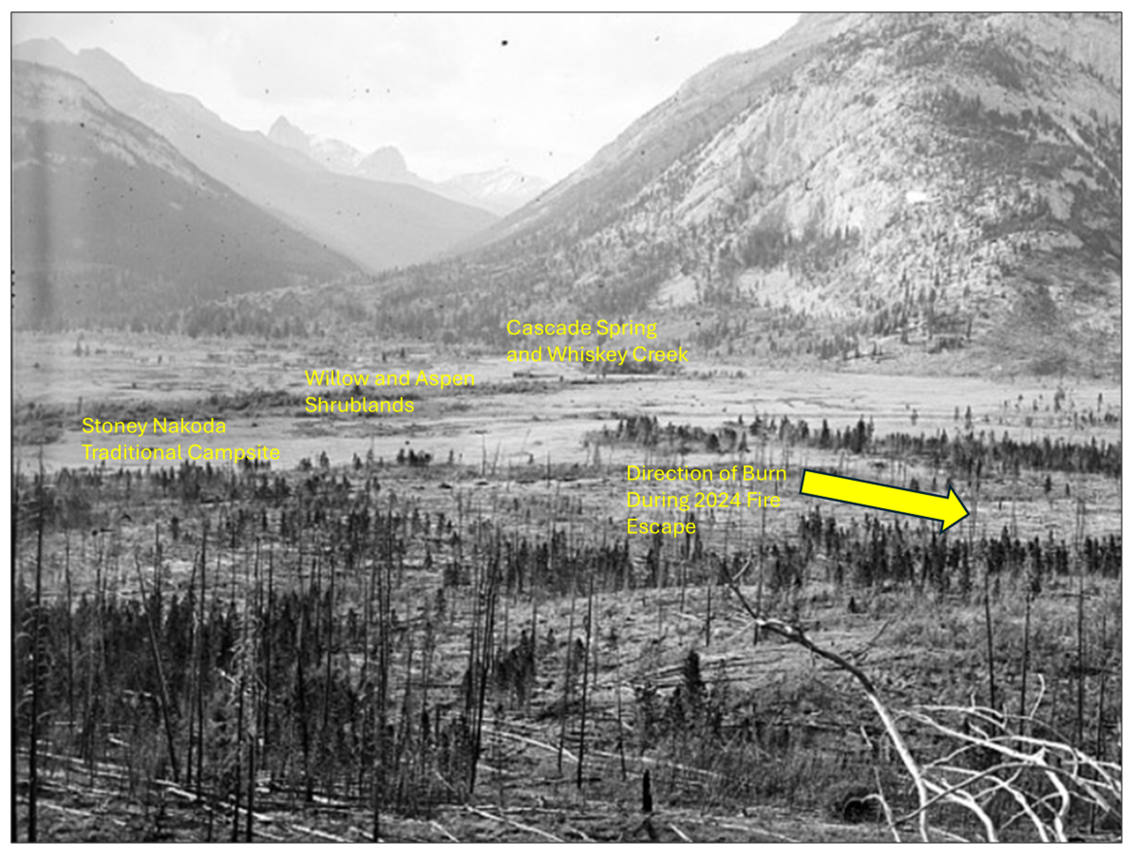
The meadows at the base of Cascade Mountain showing historic vegetation conditions (James McArthur, 1888, Mountain Legacy Project). The traditional campsite may have been routinely placed next to the creek arising from a spring at the base of Cascade Mountain. Here it would have been partially protected from wildfire on its upwind side by willow and aspen shrublands with low flammability. In contrast, the downwind meadow edge (where the 2023 prescribed fire escaped) has many dead pine and spruce trees– evidence of periodic historic higher intensity fires around the meadows. (Click photograph to enlarge).
Finally, it’s important to ask what were the objectives historic Indigenous burns? Fires were lit for many purposes including trail clearing, communication (smoke signals), rejuvenating important plant shoots and roots, thinning forests for berry-bushes, or providing habitat and movement corridors for bison, bighorn sheep, moose or elk. These varied objectives are important for evaluating fire sizes, locations, and timing. Were meadows really a specific focus of burning in the past? Or is it wiser to consider that Indigenous peoples followed the traditional cultural pattern shown elsewhere of burning yards, corridors, and mosaics (Lewis and Ferguson 1988), not just meadows, and given warm and dry weather conditions in many cases these fires spread to larger landscapes? Detailed fire history studies in and around Canadian Rockies meadows shows that this is more likely the case.
The Upshot
In summary, on the eastern slope of the Rockies “meadow burns” may largely just be a modern political and colonial contrivance, not a past cultural and ecological reality. The Indigenous peoples themselves are the logical researchers to further explore this possibility. Like the Tyrell Meadows burn shown above, Banff’s landscapes provide numerous opportunities for real-time testing for the timing and pattern of historic cultural ignitions. If these burns do spread beyond expectations, they can be held with managed fuel breaks pre-established downwind for the possibility of expected upwind “over achievements”. However, this learning is best done at some distance from hotels and busy roads. Once a fire is lit, it can rapidly change from cultural process to a high intensity biophysical phenomenon that is independent of who or what provided the spark. In this regard, Charlie Van Wagner, one of Canada’s most famous fire researchers entitled one of his conference papers: “Does Nature Really Care Who Lights the Fire?”
Return to main Bow Valley: Reduce Wildland Fire Risk section
References
Lewis, Henry T., and Theresa A. Ferguson. 1988. “Yards, Corridors, and Mosaics: How to Burn a Boreal Forest.” Human Ecology 16 (1): 57–77. https://doi.org/10.1007/BF01262026.
Parks Canada. 2020. Fire Management Plan 2020 Banff, Yoho and Kootenay National Parks. Resource Conservation Fire Management Section.
Schepens, Gabriel, Jordan H. Seider, Barry L. Wesley, Darcy L. Mathews, and Brian M. Starzomski. 2024. “Colonial Management Drives Ecological Change Following the Exclusion of Indigenous Stewardship in a Stoney Iyethka Montane Grassland, Canadian Rocky Mountains.” People and Nature 6 (6): 2618–32. https://doi.org/10.1002/pan3.10747.
White, Clifford A., Michael A. Feller, and P. Vera. 2002. “New Approaches for Testing Fire History Hypotheses.” In Managing Protected Areas in a Changing World, edited by Soren Bondrup-Nielsen, Neil W. P. Munro, Gordon Nelson, J. H. M. Willison, T. B. Herman, and P. Eagles, vol. 4. Science and Management of Protected Areas Association.White CA 2002 meadows fire history
White, Clifford A., Daniel D. B. Perrakis, Victor G. Kafka, and Timothy Ennis. 2011. “Burning at the Edge: Integrating Biophysical and Eco-Cultural Fire Processes in Canada’s Parks and Protected Areas.” Fire Ecology 7 (1): 74–106. https://doi.org/10.4996/fireecology.0701074.
Van Wagner, C. E. 1985. “Does Nature Really Care Who Starts the Fire?” Proceedings: Symposium and Workshop on Wilderness Fire (Ogden, UT), 127–28.